
Time zone AST (UTC-4) Area 122,476 km² Local time Thursday 6:08 AM | Founded May 27, 1758 Area code(s) +55 92 Population 25,948 (2012) | |
 | ||
Weather 24°C, Wind E at 6 km/h, 94% Humidity | ||
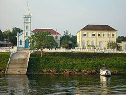
Barcelos, (also Barcellos), formerly Mariuá, is a municipality located in the State of Amazonas, northern Brazil. Its population was 32,169 (2005) and its area is 122,476 square kilometres (47,288 sq mi), making it the second largest municipality in Brazil (behind Altamira, Pará), equivalent in size to New York state in the United States and slightly larger than North Korea.
Contents
Map of Barcelos - State of Amazonas, Brazil
About
The city is served by Barcelos Airport with scheduled services to Manaus.
Since 1994, Barcelos has been the host of an annual festival celebrating ornamental fish, which is a significant source of income for the region. Project Piaba uses Barcelos as the starting point for their annual research expedition into the Rio Negro area.
The municipality contains part of the Amanã Sustainable Development Reserve. It also contains part of the Amazonas National Forest. It contains the 833,352 hectares (2,059,260 acres) Rio Unini Extractive Reserve, created in 2006.
History
Barcelos was originally named Mariuá, village of the Manaus Indians. When the captaincy of São José do Rio Negro was formed in 1755, Francisco Xavier de Mendonça Furtado, Governor General of state of Grao Para e Maranhao chose the aldeia de São José do Javari, a village founded by Carmelite Friar Matias São Boaventuras Jesuits in 1728 near the mouth of the Javari River, as its capital. It was the capital of the captaincy of São José do Rio Negro from 1755-1791, and again from 1799-1808.