
Country Philippines Founded 1815 Time zone PST (UTC+8) Local time Wednesday 8:35 PM | Region Ilocos (Region I) Barangays Area 73.25 km² Province Pangasinan | |
 | ||
District 6th District, Pangasinan Weather 26°C, Wind SW at 3 km/h, 82% Humidity | ||
Pangasinan balungao resort and natividad falls
Balungao is a 4th class municipality in the province of Pangasinan, Philippines. According to the 2015 census, it has a population of 31,106 people.
Contents
- Pangasinan balungao resort and natividad falls
- Map of Balungao Pangasinan Philippines
- Barangays
- Early settlers
- Foundation
- Mount Balungao
- Balungao Hilltop Adventure
- Longest Zipline in Pangasinan
- Education
- References
Map of Balungao, Pangasinan, Philippines
The town is located in the south-eastern part of the province bordering the province of Nueva Ecija to the south. Balungao is partially urban community with an area of 7,325 hectares (18,100 acres).
Barangays
Balungao is politically subdivided into 20 barangays.
Early settlers
The town of Balungao were first inhabited by nomadic people from the Ilocos region who found their way to the area through San Fabian, Pangasinan. They were farmers looking for places to settle down, engaging in agriculture to survive. Its origin is evident in the fact that Balungao is one of the Ilocano-speaking towns in the province where the primary language is the Pangasinense.
Foundation
Balungao was originally called Panaclaban and was a part of Cuyapo town in the adjacent province of Nueva Ecija till the latter part of 18th century. It was annexed to the town of Rosales, Pangasinan in the early part of 19th century because of its geographic location. It officially became an independent municipality in 1815.
Mount Balungao
Mount Balungao (15°51′44.90″N 120°40′57.70″E) is an extinct volcano, 382 metres (1,253 ft) ASL located in the municipality of Balungao. Its volcanic past is manifested by its physical profile and the presence of hot and cold springs. The Philippine Institute of Volcanology and Seismology (PHIVOLCS) lists Mount Balungao as an inactive volcano.
Balungao Hilltop Adventure
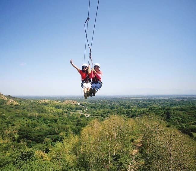
Balungao opened its doors to adventure travel tourism with the opening of Balungao Hilltop Adventure (15°52′2″N 120°41′10″E) on September 8, 2011. Located at the foot of Mount Balungao, the resort was constructed by the municipal government of Balungao and boasts the 2nd longest Zip-line in the Philippines (2011) at 600 metres (2,000 ft) long. The Balungao Hilltop Adventure also offers ATV or quad bike adventure, bungee trampoline, biking, mountain climbing, and the refurbished hot and cold spring swimming pools.
It originally started as the Mt. Balungao Hot and Cold Springs Resort under the administration of former Mayor Jose G. Peralta Jr. It was not until 2011, under the administration of the Mayor Philipp G. Peralta, that it was repackaged for adventure travelers.
Longest Zipline in Pangasinan
Balungao Hilltop Adventure offers a Zip Line with a length 600 meters which could last from 15 seconds to a minute depending on your weight and your position when you are suspended at the Zip Line. It begins from a Hill, overlooking the valley passing through another hill down to the Balungao Hot and Cold Spring Resort. It is considered as the longest Zip line in Pangasinan