
Norse name Baltey Area rank 162 Area 80 ha | OS grid reference HP661081 Highest elevation 44 m (144 ft) Automated 2004 Lieutenancy area Shetland | |
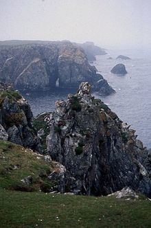 | ||
Balta (Old Norse: "Baltey") is an uninhabited island in Shetland, Scotland.
Contents
Map of Balta, United Kingdom
Geography
Balta lies off the east coast of Unst and Balta Sound. It has an area of 80 ha.
There is a natural arch on the eastern side of the island.
Balta Island Seafare and Skaw Smolts are the most northerly fish farm and fish hatchery in Britain.
History
Historic remains on the island include the ruins of a broch and of a Norse chapel dedicated to Saint Sunniva. There are no census records of more recent inhabitation.
John MacCulloch visited Balta in May 1820 to carry out the Trigonometrical Survey for the Ordnance Survey. Balta was the northernmost station of the zenith sector.
Lighthouse
The Balta Light, at the southern tip of the island was one of the first concrete structures in Shetland. The lighthouse was designed by David Stevenson and built in 1895. It was demolished in 2003 and replaced by a small solar-powered light.