
Country India Region Gwalior Time zone IST (UTC+5:30) Elevation 477 m | State Madhya Pradesh District Guna PIN 473249 Area code 07542 | |
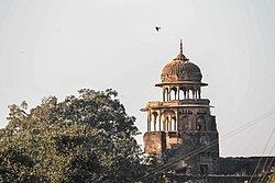 | ||
Bajrangarh is a village in the taluk of Guna, Guna District, in the Indian state of Madhya Pradesh. Bajrangarh Fort is also known as Jharkon. The fort lies at an altitude of around 92.3 metres (303 ft) and is in ruins.
Map of Bajrangarh, Madhya Pradesh
The fort is about 10 kilometres (6.2 mi) from Guna on Guna to Aron road on the bank of Chapet river around 8 kilometres (5.0 mi) south-west of Guna city. It spreads over 72 bighas of land on a high hill. The fort was built in 16-17th century by yadav raja jai narayan ) rulers of Gagron state. It came under Raghogarh state. During Akbar’s time, it was the headquarters of a mahal of the Chanderi Sarkar. During the reign of Raja Jai Singh, Daulatrao Scindia sent his General, John Baptiste to attack the fort in 1816 A.D. Raja Jai Singh was defeated and the fort was destroyed. The Bajrangarh fort had four gates in four directions. Inside the fort, Moti Mahal, Rangmahal, Ram Mandir, and Bajrang Mandir are still intact.
There is a big step well inside the complex that was used for storing drinking water for the horses. The fort also has an ancient temple which is frequented by local inhabitants.It is believed to have been constructed by the Maratha rulers in 1775.