
 | ||
Similar Henri Pittier National, Choroni Beach, Morrocoy National Park, Mochima National Park, Venezuelan Coastal Range | ||
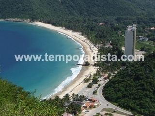
Bahía de Cata (Bay of Cata) is a beach of Aragua state (Venezuela), of large size, fine sand, clear waters and adorned by the shadow of upright coconut trees. Bahía de Cata has become a seaside area of great concurrence. It has cabins and restaurants and is located 58 km from Maracay along the road of El Limón.
Map of Cata Bay, Venezuela
With a town of 3,500 inhabitants and only 53 km from Maracay, besides of Bahía de Cata, the Araguan coast has beaches like Catica, La Ensenada de Juan Andrés and Cuyagua, Ensenadas de Chuao, Café, Puerto Maya and La Ciénaga de Ocumare, to which is accessed only by boat or by hiking through the Henri Pittier National Park.
References
Bahía de Cata Wikipedia(Text) CC BY-SA