
Postal code 739 01 Area 12.83 km² Local time Tuesday 11:35 PM | First mentioned 1434 Website www.baska.cz Elevation 313 m Population 3,398 (2006) | |
 | ||
Weather 9°C, Wind S at 32 km/h, 64% Humidity | ||
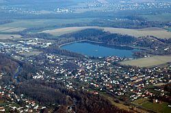
Baška is a municipality in Moravian-Silesian Region of the Czech Republic. It is located on Ostravice River, about 5 km southeast of Frýdek-Místek. The municipality has a population of 3,398 (2006) and consists of three villages (Baška, Hodoňovice and Kunčičky u Bašky) merged in 1960. On the northeast edge of Baška there is a shallow water reservoir (max. depth 6 m, area 33 ha) used for recreational purposes (bathing, fishing, caravan site).
Contents
Map of 739 01 Ba%C5%A1ka, Czechia
History
The village was first mentioned in 1434 as Bassky. Politically it belonged to the Duchy of Teschen, a fee of the Kingdom of Bohemia, which after 1526 became part of the Habsburg Monarchy. In 1573 it was sold as one of 16 villages and the town of Friedeck and formed a state country split from the Duchy of Teschen.
After World War I and fall of Austria-Hungary it became a part of Czechoslovakia. In March 1939 it became a part of Protectorate of Bohemia and Moravia. After World War II it was restored to Czechoslovakia.
In 1960 Silesian Baška was merged with Moravian 'Hodoňovice and Kunčičky u Bašky.