
Suburban Development Area Nutana Annexed 1910-1919 Area 146 ha Population 3,214 (2007) | Neighbourhood Avalon Construction 1946-1970 Local time Friday 2:49 AM | |
 | ||
Weather -7°C, Wind SE at 24 km/h, 72% Humidity Restaurants Somewh Else Pub & Grill, Asian Kitchen Ltd, Stan's Place, Tino's Takeout and Deliv, Pizza 306 | ||
Avalon is a mostly residential neighbourhood located in south-central Saskatoon, Saskatchewan, Canada. It is a suburban subdivision, consisting mostly of low-density, single detached dwellings. As of 2007, the area is home to 3,214 residents. The neighbourhood is considered a middle-income area, with an average family income of $65,000, an average dwelling value of $168,444 and a home ownership rate of 77.3%. According to MLS data, the average sale price of a home as of 2013 was $352,359.
Contents
- Map of Avalon Saskatoon SK Canada
- History
- Government and politics
- Education
- Parks and recreation
- Public services
- Commercial
- Location
- References
Map of Avalon, Saskatoon, SK, Canada
History
Most of the land for the neighbourhood was annexed by the city between 1910 and 1919, with the remaining southern piece annexed between 1960 and 1969. A 1913 map shows that the present-day Avalon area overlaps three registered subdivisions of the day: Avalon in the northwest, Pacific Addition in the east and railway stock yards in the south. Home construction, however, did not begin in earnest until after World War II. The layout of the streets reflects the changing urban planning philosophies of the day as the land was developed. The north part of the neighbourhood follows a traditional grid pattern. By the 1950s, the design of residential neighbourhoods used a modern system of curving residential streets, feeding into collector roads that connected to arterial roads. Thus, the southern part of the neighbourhood follows this design practice.
John Lake School was opened in 1958. Georges Vanier School was opened that same year, and renovated in 1963.
Residential build-out in Avalon was mostly completed by the late 1960s, however some additional residential development occurred south of Glasgow Street and west of Clarence Avenue in the mid-1990s, along with some limited remnant development west of Melrose Avenue in the 1980s. As noted below, plans for the southwest extension of Circle Drive initially caused some concern; construction of an interchange at Clarence Avenue and Circle, in the planning since the 1960s, was completed by the late 2000s, facilitating resident access to the freeway and to the Stonebridge commercial area to the southeast.
Government and politics
Avalon exists within the federal electoral district of Blackstrap. It is currently represented by Lynne Yelich of the Conservative Party of Canada, first elected in 2000 and re-elected in 2004 and 2006.
Provincially, the neighbourhood is within the boundaries of the Saskatoon Eastview constituency. It is currently represented by Judy Junor of the Saskatchewan New Democratic Party, first elected in 1998 and re-elected in 1999, 2003 and 2007.
In Saskatoon's non-partisan municipal politics, Avalon lies within ward 7. It is currently represented by Councillor Bob Pringle, who was elected to city council in 2006 and re-elected by acclamation in 2009. Previously, he served in provincial politics as the NDP MLA for Saskatoon Eastview from 1988 to 1998.
Education
Parks and recreation
The Avalon Community Association exists to represent the educational, recreational, and social needs of residents, to promote a sense of community and enhance quality of life in the area.
Public services
Avalon is a part of the east division of the Saskatoon Police Service's patrol system. Saskatoon Fire & Protective Services' east division covers the neighbourhood. Transit services to Avalon are provided by Saskatoon Transit on routes No. 6 (Clarence - Broadway) and 13 (Lawson - Exhibition).
Commercial
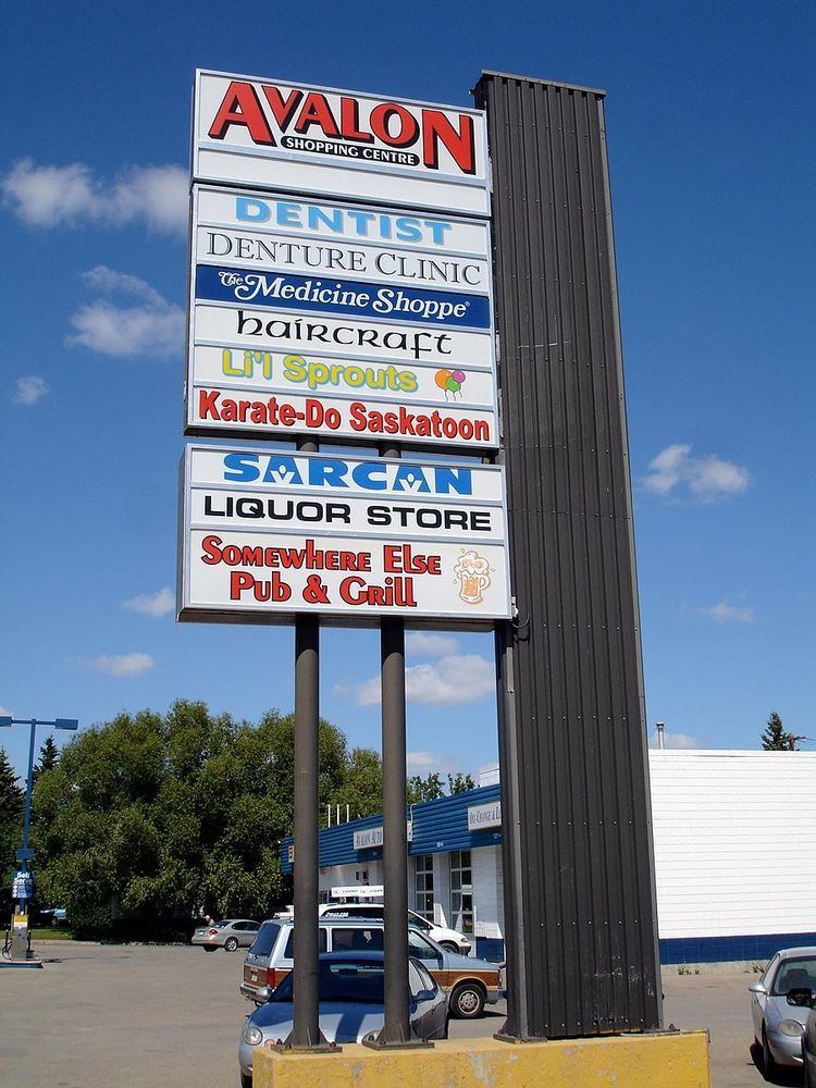
The main commercial development is the Avalon Shopping Centre, a strip mall located on the corner of Broadway Avenue and Cascade Street. There are also two small commercial areas along Ruth Street: one between Lorne and Vernon Avenues, and another at Melrose Avenue. In addition, there are 40 home-based businesses in the neighbourhood. It is also separated by an interchange from the Stonebridge "big-box" shopping centre to the immediate southeast.
Location
Avalon is located within the Nutana Suburban Development Area. It is bounded by Ruth Street to the north, Circle Drive to the south, Idylwyld Drive to west, and Clarence Avenue to the east. Roads are laid in a grid fashion in the north part of the neighbourhood, while the south part features crescents and cul-de-sacs.
Vernon Avenue is a local oddity. On maps it is a one-block long one-way street for northbound traffic between Bute and Ruth Streets. It actually begins at Bute Street as the back alley for houses along McPherson Avenue to the east. It then merges with the Idylwyld Freeway offramp to become a true road until terminating at Ruth Street. St. George Avenue in the neighbouring Exhibition neighbourhood is similarly used as the southbound exit from the Idylwyld Freeway to Ruth Street. The combination of houses and exiting freeway traffic makes this type of street a rarity in Saskatoon.
Early planning for the southwestern extension of Circle Drive led to some concerns as early concepts for the proposed flyover interchange with Idylwyld Freeway would have required demolition of many homes on or near Glasgow Street. The final design, which opened to traffic on July 31, 2013, sacrificed some greenspace in the southwest corner of the community, and the construction of sound attenuation fencing, but otherwise required no home demolition.