
Population 361 (2011 census) Postal code 4213 | Postcode(s) 4213 | |
 | ||
Austinville is a small, historic suburb of Queensland covering approximately 20 kilometres squared and situated in the Gold Coast Hinterland between Mudgeeraba and Springbrook. At the 2011 Australian Census the suburb recorded a population of 361.
Contents
Map of Austinville QLD 4213, Australia
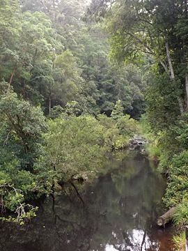
Austinville is located in a valley through which flows Mudgeeraba Creek and the rugged Nimmel Range loom in the distance. Significant rainforest exists in the area. Areas in the south are protected within Springbrook National Park.
History
Austinville settlement was established as a banana plantation in 1934, making it one of the Gold Coast's oldest suburbs. It was started as an attempt to resettle unemployed people on the land following the Great Depression, and therefore lift the economy. It was named after the minister for labour at the time, W Austin, who encouraged the building of many of these plantations throughout the state. Land was cleared and divided into blocks and properties, a school was constructed and 50 or so small homes were built too. Mudgeeraba Creek flowed behind the homes along the valley floor, and the rugged Nimmel Range bordered on the settlement's western side. The settlement was very short lived. By 1939, within just 5 years, most families had left the area. Rainforest has crept back into much of the once banana farming valley, and the area remains dwarfed by the surrounding conservation area.