Girish Mahajan (Editor)

Aurora, Isabela

Updated on
Edit
Like
Comment
Share on FacebookTweet on TwitterShare on LinkedInShare on Reddit
Country
  
Philippines

Time zone
  
PST (UTC+8)

Area
  
115.6 km²

Local time
  
Thursday 9:50 PM

Barangays
  
33

ZIP code
  
3316

Province
  
Isabela

Dialling code
  
78

Aurora, Isabela

Region
  
Cagayan Valley (Region II)

District
  
5th District of Isabela

Weather
  
23°C, Wind NW at 10 km/h, 86% Humidity

Neighborhoods
  
Villa Fugu, Bagnos, Bagho, Bannagao

Aurora' is a 3rd class municipality in the province of Isabela, Philippines. According to the 2015 census, it has a population of 35,017 people.

Contents

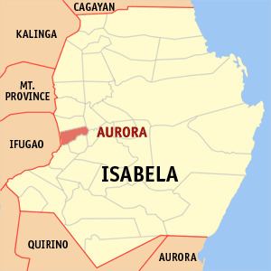
Map of Aurora, Isabela, Philippines

Barangays

Aurora is politically subdivided into 33 barangays. It became a Municipal District on August 27, 1927.

  • Apiat
  • Bagnos
  • Bagong Tanza
  • Ballesteros
  • Bannagao
  • Bannawag
  • Bolinao
  • Sto. Niño (Caipilan)
  • Camarunggayan
  • Dalig-Kalinga
  • Diamantina
  • Divisoria
  • Esperanza East
  • Esperanza West
  • Kalabaza
  • Rizalina (Lapuz)
  • Macatal
  • Malasin
  • Nampicuan
  • Villa Nuesa
  • Panecien
  • San Andres
  • San Jose (Pob.)
  • San Rafael
  • San Ramon
  • Santa Rita
  • Santa Rosa
  • Saranay
  • Sili
  • Victoria
  • Villa Fugu
  • San Juan (Pob.)
  • San Pedro-San Pablo (Pob.)
  • References

    Aurora, Isabela Wikipedia