
Country United States County Rawlins Area code(s) 785 Elevation 871 m Population 1,225 (2013) | Time zone Central (CST) (UTC-6) FIPS code 20-03150 Zip code 67730 Local time Wednesday 2:17 AM | |
 | ||
Weather -2°C, Wind W at 21 km/h, 67% Humidity | ||
Atwood is a city in and the county seat of Rawlins County, Kansas, United States. As of the 2010 census, the city population was 1,194.
Contents
- Map of Atwood KS 67730 USA
- History
- Geography
- Climate
- Area attractions
- Area events
- 2010 census
- 2000 census
- Primary and secondary education
- Highway
- Rail
- Airport
- Notable people
- References
Map of Atwood, KS 67730, USA
History
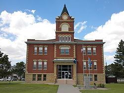
In 1875, T.A. Andrews and J.M. Matheny traveled to Rawlins County and started a town site about two miles east of the current city. The city of Attwood (with two t's) was named after Attwood Matheny, the 14-year-old son who accompanied his father on the journey. In 1882, the U.S. Post Office requested permission to drop one "t" thus becoming Atwood. In 1881, Atwood became the county seat of Rawlins County.
Geography
Atwood is located at 39°48′32″N 101°2′29″W (39.808971, -101.041370). According to the United States Census Bureau, the city has a total area of 1.10 square miles (2.85 km2), of which 1.04 square miles (2.69 km2) is land and 0.06 square miles (0.16 km2) is water.
Climate
According to the Köppen Climate Classification system, Atwood has a semi-arid climate, abbreviated "BSk" on climate maps.
Area attractions
Area events
2010 census
As of the census of 2010, there were 1,194 people, 568 households, and 299 families residing in the city. The population density was 1,148.1 inhabitants per square mile (443.3/km2). There were 666 housing units at an average density of 640.4 per square mile (247.3/km2). The racial makeup of the city was 97.2% White, 0.2% African American, 0.3% Native American, 0.1% Asian, 1.0% from other races, and 1.3% from two or more races. Hispanic or Latino of any race were 2.9% of the population.
There were 568 households of which 20.2% had children under the age of 18 living with them, 43.0% were married couples living together, 6.2% had a female householder with no husband present, 3.5% had a male householder with no wife present, and 47.4% were non-families. 44.7% of all households were made up of individuals and 23.2% had someone living alone who was 65 years of age or older. The average household size was 2.03 and the average family size was 2.84.
The median age in the city was 50.9 years. 20.3% of residents were under the age of 18; 4.7% were between the ages of 18 and 24; 17% were from 25 to 44; 29.5% were from 45 to 64; and 28.6% were 65 years of age or older. The gender makeup of the city was 47.4% male and 52.6% female.
2000 census
As of the census of 2000, there were 1,279 people, 577 households, and 347 families residing in the city. The population density was 1,229.7 people per square mile (474.8/km²). There were 708 housing units at an average density of 680.7 per square mile (262.8/km²). The racial makeup of the city was 98.67% White, 0.16% African American, 0.23% Native American, and 0.94% from two or more races. Hispanic or Latino of any race were 0.39% of the population.
There were 577 households out of which 23.4% had children under the age of 18 living with them, 52.0% were married couples living together, 6.6% had a female householder with no husband present, and 39.7% were non-families. 36.9% of all households were made up of individuals and 20.3% had someone living alone who was 65 years of age or older. The average household size was 2.12 and the average family size was 2.78.
In the city, the population was spread out with 21.7% under the age of 18, 3.5% from 18 to 24, 21.7% from 25 to 44, 23.5% from 45 to 64, and 29.6% who were 65 years of age or older. The median age was 48 years. For every 100 females there were 89.8 males. For every 100 females age 18 and over, there were 84.2 males.
As of 2000 the median income for a household in the city was $30,221, and the median income for a family was $39,375. Males had a median income of $27,768 versus $19,063 for females. The per capita income for the city was $16,161. About 4.5% of families and 10.7% of the population were below the poverty line, including 10.8% of those under age 18 and 10.7% of those age 65 or over.
Primary and secondary education
Atwood is part of Unified School District 105. The district has two schools in Atwood:
Highway
US-36 and K-25 highways cross in Atwood.
Rail
Nebraska Kansas Colorado Railway passes through Atwood.