
- elevation 2,837 m (9,308 ft) Length 180 km Basin area 5,540 km² | - elevation 1,807 m (5,928 ft) Basin area 5,540 km² Mouth Naryn River | |
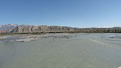 | ||
The At-Bashi River (Kyrgyz: Атбашы дарыясы) is a left tributary of the Naryn River in Naryn Province of Kyrgyzstan. The river is formed at the north slope of Jangy-Jer Range by confluence of rivers Ulan and Jangy-Jer. The basic hydrological characteristics are: length - 180`km, watershed - 5,540 km², average altitude - 3,060 m, annual average flow rate - 33.1 m³/s, and average specific discharge - 5.98 l/s•km² Settlements located along the banks of At-Bashi River include: At-Bashi, Taldy Suu, Bosogo.
References
At-Bashi River Wikipedia(Text) CC BY-SA