
Population 449 (2011) Civil parish Astley Local time Monday 7:59 PM | OS grid reference SJ528188 Dialling code 01939 | |
 | ||
Weather 2°C, Wind SW at 8 km/h, 86% Humidity | ||
Astley is a small village and civil parish in Shropshire, England. The official 2001 census recorded 454 people living in the parish and 116 in the village itself, falling slightly to 449 at the 2011 Census.
Contents
Map of Astley, UK
The village lies near to (and between) the A53 and A49 roads.
Upper Astley is a hamlet on the A53 about half a mile to the south of the village of Astley. There is a public house there - the Dog in the Lane.
History
The village was featured in the Domesday Book of 1086 as a small settlement, with no church, but with a manor, and was called "Hesleie". Back then it was part of the Baschurch Hundred.
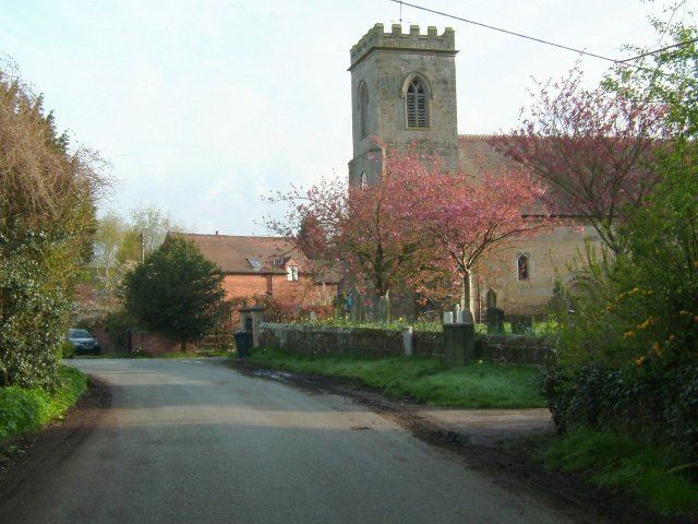
The village of Astley today is scenic and quaint, and consists of a number of old dwellings of architectural interest. For this reason a Conservation Area covers almost the entirety of the village, including all of the dwellings there. Astley Conservation Area was designated in 1988 and covers and area of 23.5 hectares/57 acres. It is currently being reviewed and the boundaries may soon be altered slightly. The Conservation Area is centred on the church of St Mary's which dates back to the 12th century. During the medieval era the area was partly administered by nearby Haughmond Abbey (now a ruin).
The oldest existing dwelling is Church House, built in the early 17th century. Church Farmhouse is thought to be 18th century and Firs Farmhouse is dated 1760. There are a number of substantial Victorian era houses too, with large, landscaped gardens and grounds. The village therefore has a great number of fine mature trees.
The most impressive dwelling in Astley today is Astley House, originally a small 18th-century country house set within its own ornamental grounds. The house and its gardens were remodelled in the 19th century and the house grew in stature greatly. The main part of the building is now in the form of a Classical temple, in a Corinthian style. The coach house flanking the main building is also in the style of a Greek Doric temple with a portico in antis.
Nearby is a monument to King George IV (the famous Prince Regent of the time) which too is in an ancient Roman/Greek fashion. The grounds of Astley House extend quite some distance and are similarly landscaped to a high order.
Astley House, Church House, Church Farmhouse and the Firs Farmhouse are all listed buildings. There are a number of other interesting old dwellings and outbuildings in a village that has grown slowly over time (despite development continuing apace nearby, notably in Battlefield. The village is effectively by-passed by the A53 and A49 roads, although there were plans in the 1980s to re-route the A53 closer to the village in a wider scheme of road building north of Shrewsbury. Fortunately this did not happen, instead the new A5124 "Battlefield Link Road" was built closer to Shrewsbury in the late 1990s.
St Mary's Church in the village has what could be the county's oldest church bell, dating back to 1270. In 2012 this bell, now named Mary (after the church's saint), was restored and rehung in the church tower, along with a restored 18th-century bell which is now named Elizabeth (after the present Queen).