
Population 6,596 (2011 census) Area 3.3 km² | Postcode(s) 3195 Postal code 3195 | |
 | ||
Location 27 km (17 mi) from Melbourne | ||
Aspendale Gardens is a suburb in Melbourne, Victoria, Australia, 27 km south-east of Melbourne's central business district. Its local government area is the City of Kingston. According to the 2011 Census, Aspendale Gardens had a population of 6,596.
Map of Aspendale Gardens VIC 3195, Australia
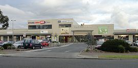
The main road that goes through Aspendale Gardens is called Wells Road (State Route 23). The M11 Mornington Peninusla Freeway and Spingvale Road/Edithvale Road (Route 40) also run along the border of Aspendale Gardens. In Aspendale Gardens, there is a 7-Eleven petrol station, a shopping centre (which includes an IGA, a Liquor Store, a Bakery, a Hairdresser, a Chemist, a Fish and Chip shop and a Pizza Shop, a dentist and wellness centre, a kindergarten, a primary school (named Aspendale Gardens Primary School), a vet, a community centre, a car wash, and a retirement village named Richfields.
There are many open areas and playgrounds facilities in Aspendsale Gardens including an cricket oval behind Aspendale Gardens Primary School, 6 playgrounds and over 20 large grassy areas spaced throughout the housing estates. There are many walking trails throughout Aspendale Gardens, including the Long Beach Trail (from the Patterson River to the Mordialloc Pier), the Mordialloc Creek Trail (from the Waterways Trail to Mordialloc Pier), the Waterways Trail (from Wells Road to Waterways) and the Aspendale Gardens Trail (from 7 - Eleven to the Long Beach Trail outside St. Louis de Montford School).