
Country United States Time zone Eastern (EST) (UTC-5) Elevation 216 m Zip code 43103 Local time Sunday 11:13 AM | State Ohio FIPS code 39-02680 Area 6.5 km² Population 4,112 (2013) Area code 740 | |
 | ||
Weather 1°C, Wind SW at 13 km/h, 53% Humidity | ||
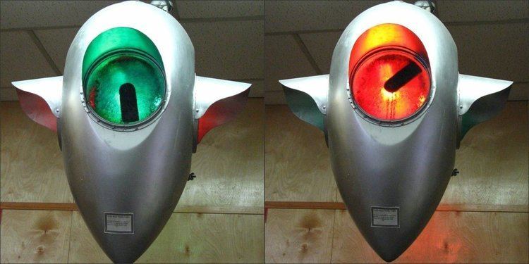
Ashville museum ashville ohio
Ashville is a village in Pickaway County, Ohio, United States. The population was 4,097 at the 2010 census. Ashville is located 22 miles south of Columbus, Ohio and 11 miles north of Circleville, Ohio.
Contents
- Ashville museum ashville ohio
- Map of Ashville OH 43103 USA
- History
- Places of Interest
- Schools
- Festivals
- Geography
- 2010 census
- 2000 census
- Government
- Notable residents
- References
Map of Ashville, OH 43103, USA
History
In 1812 two distilleries were built near Ashville and were owned by William and Richard Staige (Stage). The land that is now Ashville was at that time primarily the property of Richard Staige. After many years he sold his distillery to Mahlon Ashbrook, who did a large business with his brother Absolom. He also built a grist mill on Walnut Creek about 1845 and owned a large store that was run by his sister Iva "Ivy" and her husband Daniel Kellerman. Kellerman was the first postmaster in Ashbrook (later Ashville). The Ashbrook's enterprises failed in 1855. From that time, until the construction of the Scioto Valley Railroad through Ashville and the advent of a depot in 1876, business was slow. Ashville was incorporated in 1882, with the first mayor being W. R. Julian.
A historical museum, Ohio's Small Town Museum, is operated in the community. The museum, established in 1975, claims to be home to America's oldest working traffic light, which directed traffic in downtown Ashville until 1982. This signal was designed by local resident Teddy Boor.
Ashville is featured in the Together Concepts video production "We Are..Teays Valley". The video depicts a surprising number of achievements and innovations, as well as connections to American and world history.
The Puppeteers of America organization was first incorporated in Ashville in 1961 and the Puppetry Journal was published by the Pickaway Publishing Company in Ashville.
Ohio's oldest surviving 17-star U.S. flag representing Ohio's entry into the Union of States was found in an attic in a house on Long Street in Ashville.
Places of Interest
Slate Run Living Historical Farm is a working farm circa 1880. The farm belonged to the Oman family and is where patented gyroplane inventor John Oman was raised.
Snake Den Mounds are an upland mound grouping that is located 5 miles east of Ashville, noted as much as a hibernation spot for blue racer snakes as for the curious collection of silver nuggets found in hollow concretions.
Schools
Festivals
Ashville's Fourth of July Celebration has been featured in articles by the New York Times and the Philadelphia Enquirer. The celebration was captured by famous social realist artist and photographer, Ben Shahn, in 1938 for the Farm Security Administration. Thousands of people come from all over the state to enjoy the parades, fish sandwiches, musical entertainment, games, rides, small town atmosphere, concessions, and fireworks.
The Ashville Viking Festival has been drawing crowds since 2003. The focus is on fun and the 10th Century.
Geography
Ashville is located at 39°43′03″N 82°57′10″W.
According to the United States Census Bureau, the village has a total area of 2.51 square miles (6.50 km2), all of it land.
2010 census
As of the census of 2010, there were 4,097 people, 1,598 households, and 1,100 families residing in the village. The population density was 1,632.3 inhabitants per square mile (630.2/km2). There were 1,731 housing units at an average density of 689.6 per square mile (266.3/km2). The racial makeup of the village was 96.7% White, 1.0% African American, 0.4% Native American, 0.3% Asian, 0.1% from other races, and 1.4% from two or more races. Hispanic or Latino of any race were 1.4% of the population.
There were 1,598 households of which 41.6% had children under the age of 18 living with them, 45.7% were married couples living together, 15.6% had a female householder with no husband present, 7.6% had a male householder with no wife present, and 31.2% were non-families. 25.5% of all households were made up of individuals and 8.8% had someone living alone who was 65 years of age or older. The average household size was 2.56 and the average family size was 3.05.
The median age in the village was 32.8 years. 29.3% of residents were under the age of 18; 9.8% were between the ages of 18 and 24; 29.6% were from 25 to 44; 21.9% were from 45 to 64; and 9.5% were 65 years of age or older. The gender makeup of the village was 48.5% male and 51.5% female.
2000 census
As of the census of 2000, there were 3,174 people, 1,243 households, and 872 families residing in the village. The population density was 2,035.8 people per square mile (785.6/km2). There were 1,337 housing units at an average density of 857.5 per square mile (330.9/km2). The racial makeup of the village was 97.83% White, 0.19% African American, 0.32% Native American, 0.06% Asian, 0.19% from other races, and 1.42% from two or more races. Hispanic or Latino of any race were 1.07% of the population.
There were 1,243 households out of which 40.4% had children under the age of 18 living with them, 52.5% were married couples living together, 13.4% had a female householder with no husband present, and 29.8% were non-families. 24.9% of all households were made up of individuals and 9.9% had someone living alone who was 65 years of age or older. The average household size was 2.55 and the average family size was 3.03.
In the village, the population was spread out with 29.6% under the age of 18, 9.6% from 18 to 24, 33.8% from 25 to 44, 17.7% from 45 to 64, and 9.3% who were 65 years of age or older. The median age was 31 years. For every 100 females there were 93.5 males. For every 100 females age 18 and over, there were 85.3 males.
The median income for a household in the village was $40,778, and the median income for a family was $47,092. Males had a median income of $35,236 versus $22,231 for females. The per capita income for the village was $16,645. About 6.3% of families and 9.5% of the population were below the poverty line, including 11.5% of those under age 18 and 6.0% of those age 65 or over.
Government
Ashville is governed by the mayor-council system of government. In 2009, the mayor was Chuck Wise, and the members of council were Nelson Embrey, Gayle Blankenship, Chester Gloyd, Brian Garvine, Keith Moore, Terry L. Moore. The village employs a village administrator; in 2009, this position was occupied by Franklin Christman.