
Population 7,586 (2011 census) Postal code 3147 | Postcode(s) 3147 Area 2.9 km² | |
 | ||
Location 12 km (7 mi) from Melbourne | ||
Ashburton is a suburb of Melbourne, Victoria, Australia, 12 kilometres (7.5 mi) southeast of Melbourne's Central Business District. Its local government area is the City of Boroondara. At the 2011 census, Ashburton had a population of 7,586.
Contents
Map of Ashburton VIC 3147, Australia
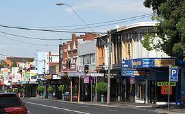
Ashburton is renowned for its expansive parklands, bike trails, large leafy green blocks, range of excellent primary schools, proximity to private schools, access to recreational facilities, public transport and the vibrant High Street shopping strip.
History
Ashburton Post Office opened on 15 December 1927, some time after the rail line was electrified in 1924. A Solway office in the south of the suburb was open from 1954 until 1978.
Today
Ashburton features a retail area around High Street, has two train stations (Ashburton and Alamein) and contains a branch of the Boroondara Library.
The suburb contains student housing (operated by the Ashburton Baptist Church) due to its proximity to the Holmesglen Institute of TAFE, Monash University (Caulfield and Clayton campuses), Deakin University (Burwood campus) and Swinburne University (Hawthorn campus). The Ashburton Baptist, Catholic and Anglican Churches also run the Ashburton Asylum Seeker Support Group.
Education
Ashburton is served by three primary schools: St Michael's Parish School is a Catholic co-ed primary school located on High Street. Solway Primary School and Ashburton Primary School are government primary schools located on Winton Road and Fakenham Road respectively.
Recreation
Ashburton hosts the following recreational interests: