
Time zone UTC-3 (UTC-3) Elevation 755 m Population 83,939 (2015) | HDI (2000) 0,788 medium Area 96.17 km² Local time Saturday 5:53 PM | |
 | ||
Weather 22°C, Wind NE at 3 km/h, 83% Humidity | ||
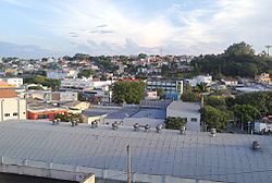
Arujá is a city in the state of São Paulo in Brazil. It is part of the Metropolitan Region of São Paulo. The population is 83,939 (2015 est.) in an area of 96.17 km². Its boundaries are Santa Isabel in the north and the northeast, Mogi das Cruzes in the southeast, Itaquaquecetuba in the south and Guarulhos to the west and the northwest.
Map of Aruj%C3%A1, State of S%C3%A3o Paulo, Brazil
The municipality contains part of the 292,000 hectares (720,000 acres) Mananciais do Rio Paraíba do Sul Environmental Protection Area, created in 1982 to protect the sources of the Paraíba do Sul river.
References
Arujá Wikipedia(Text) CC BY-SA