
Population 1,122 (2013 Estimate) County County Antrim Sovereign state United Kingdom Local time Wednesday 6:10 PM District Moyle District Council Ni assembly North Antrim | Irish grid reference D067328 Country Northern Ireland Post town BALLYMONEY Province Ulster Dialling code 28 UK parliament constituency North Antrim | |
 | ||
Weather 4°C, Wind NE at 10 km/h, 90% Humidity | ||
Armoy (from Irish: Oirthear Maí) is a small village and civil parish in County Antrim, Northern Ireland. It is 5.5 miles (9 km) southwest of Ballycastle and 8 miles (13 km) northeast of Ballymoney. According to an estimate in 2013 by the Northern Ireland Statistics and Research Agency it had a population of 1,122. The village is on the River Bush between two of the nine Glens of Antrim; Glenshesk and Glentaisie. The Armoy area also includes half of Knocklayd mountain which lies to the northeast of the village.
Contents
- Map of Armoy Ballymoney UK
- History
- Places of interest
- Events
- Community development
- Transport
- The Troubles
- People
- References
Map of Armoy, Ballymoney, UK
It is one of the bigger villages in the Moyle area and has two primary schools, shops, a post office, public houses and other community facilities. The village was dominated by public sector housing for many years, but in the late 1980s and early 1990s, a new housing development was built. Many more new developments have been built since then.
The River Bush once flowed directly north to the sea at Ballycastle. However, after the last glacial event in Ulster deposited the Armoy Moraine (on which the church and round tower sit), the river was deflected to the west and it now reaches the sea through Bushmills and Portballantrae.
History
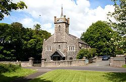
A monastic settlement which was founded by Saint Patrick in the 5th Century formerly sat to the northeast of the present day village, in the area of what is now St. Patrick's Parish Church. The site was excavated recently and archaeologists uncovered artifacts which date the location to the 6th century. The actual centre of the monastic settlement has yet to be determined, though many scholars believe it may be higher up the slope behind the graveyard on unexcavated ground.
The monastic settlement is said to be built on land given to Patrick by Fergus Mor MacEarca who would succeed his father to become the first Christian king in Ireland. Saint Olcán was a follower of Patrick who came from the area, and was baptised at Dunseverick by Patrick and later became Bishop of Armoy. One of the local primary schools still carries his name.
It is suggested that the original site of the village was built around the monastery and the round tower. However, during the Norman period the village moved to its present-day location on the banks of the River Bush to accommodate the Norman operated mills which demanded large volumes of water. Therefore, a location by the riverbank was much more suitable.
The area surrounding the present day church is of special significance as it has several oval shaped tunnels which have been dug under the rock all the way down to a cave at the Lagge crossroads below the church. This tunnel from the tower to the crossroads was used as an escape route as it leads down to the River Bush. The word Lagge is of significance as it translates as hollow and legend has it that a giant lifted an ‘L’- shaped section of the ground at Lagge Cross and threw it into the sea creating Rathlin Island.
Places of interest
Events
In recent years Armoy has played host to what has become one of the stand out events in the Irish Road Racing callender, The Armoy Road Race, also known as "The Race of Legends".
The event takes place at the end of July/start of August every year and takes place on Armoy's 3 mile long circuit. The grid for the races is set up in a grand prix style with up to 27 riders starting each race. The start/finish line is located along the A44 Hillside Road just to the north of the village on the main road to Ballycastle.
Community development
The commercial and community life of the village has been greatly enhanced by a community regeneration project at the junction of Main Street and Drones Road. The Tilley Molloy Project, implemented under the International Fund for Ireland’s Community Regeneration and Improvement Special Programme (CRISP), was undertaken by Armoy Community Development Association and completed in 2000. This redevelopment of a key derelict site at the entrance to the village provided four shop units, four apartments, community care facilities and public toilets. The physical environment of the village has been further enhanced by a new Riverside Park developed by the District Council, and an environmental improvement scheme on Main Street carried out as part of the CRISP project.
Transport
Armoy railway station opened on 18 October 1880 and was shut on 3 July 1950. It was on the Ballycastle Railway, a narrow gauge railway which ran for 17 miles linking Ballycastle to Ballymoney, on the Belfast and Northern Counties Railway (BNCR), later Northern Counties Committee (NCC), main line to Londonderry.
The Troubles
On 15 April 1978 RUC officer John Moore was killed by an IRA booby trap bomb attached to his car.