
Country United States County Shelby Time zone Central (CST) (UTC-6) Zip code 38002 Population 11,664 (2013) | State Tennessee Elevation 282 ft (86 m) Area code(s) 901 Local time Wednesday 7:51 AM | |
 | ||
Weather 16°C, Wind SW at 16 km/h, 100% Humidity Neighborhoods Trails of Arlington, Dawson Landing | ||
Arlington is a town in Shelby County, Tennessee. The population was 2,569 at the 2000 census and 11,517 at the 2010 census, for a gain of 348.3% during the decade. The 2010 US Census shows that Arlington is the 2nd fastest growing community in the State of Tennessee. It is one of seven municipalities in Shelby County.
Contents
Map of Arlington, TN, USA
History
Arlington has been called Shelby County’s best-kept secret, as it has remained a small quiet rural town for two centuries.
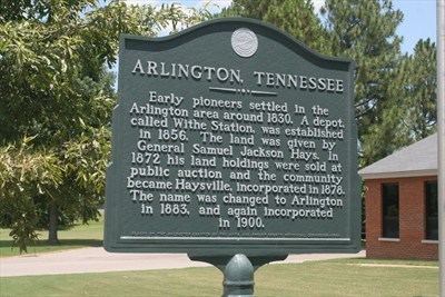
Settlers came to the area in the 1830s, and many of their descendants still live in the town. Originally known as Haysville, the town was named after the original landowner, Samuel Jackson Hays, a nephew of President Andrew Jackson. The area began to grow with the development of the Memphis and Ohio Railroad and the creation of Withe Depot within its boundaries. By 1856, about 200 people called Haysville home. The outbreak of yellow fever in Memphis in 1878 contributed to the stagnant population as the town fathers quarantined the area, forbidding outsiders from entering the town. The town was incorporated as Haysville in 1878.
In 1883 the town's name was changed to Arlington due to the post office being unable to use the name Haysville. In 1900 the town was incorporated again. Captain Henry Pittman, who lived in Haysville, had visited Washington, D.C. and Arlington National Cemetery and was inspired to call the town Arlington.
Geography
According to the United States Census Bureau, the town has a total area of 20.4 square miles (53 km2), of which 0.05% is water.
2010 Census
As of the census of 2010, there were 11,517 people, and 3,739 households. The population density was 565 people per square mile (48.6/km²). The racial makeup of the town was 81.24% White, 13.84% African American, 0.16% Native American, 1.80% Asian, 0.86% from other races, 2.08% from two or more races, and .02% from Native Hawaiian and Other Pacific Islander. Hispanic or Latino of any race were 2.98% of the population.
There were 3,739 households out of which 35.23% were 1-2 person occupied, 48.02% were 3-4 person occupied, 15.32% were 5-6 person occupied, 1.42% were 7 or more person households and 4.2% were listed as unoccupied.
In the town, the population was spread out with 37.53% under the age of 18, 3.47% from 18 to 24, 35.62% from 25 to 44, 19.20% from 45 to 64, and 4.19% who were 65 years of age or older. The median age was 32.2 years. The population was 49% male and 51% female.
The estimated median income for a household in 2009 was $82,272, and the median income for a family was $85,779. The per capita income for the town was $29,468.
2000 Census
As of the census of 2000, there were 2,569 people, 794 households, and 669 families residing in the town. The population density was 125.8 people per square mile (48.6/km²). There were 928 housing units at an average density of 45.4 per square mile (17.5/km²). The racial makeup of the town was 74.23% White, 23.01% African American, 0.47% Native American, 0.62% Asian, 0.54% from other races, and 1.13% from two or more races. Hispanic or Latino of any race were 1.13% of the population.
There were 794 households out of which 42.8% had children under the age of 18 living with them, 67.1% were married couples living together, 13.5% had a female householder with no husband present, and 15.7% were non-families. 12.2% of all households were made up of individuals and 5.7% had someone living alone who was 65 years of age or older. The average household size was 2.88 and the average family size was 3.15.
In the town, the population was spread out with 26.1% under the age of 18, 5.8% from 18 to 24, 37.6% from 25 to 44, 22.6% from 45 to 64, and 8.0% who were 65 years of age or older. The median age was 36 years. For every 100 females there were 97.5 males. For every 100 females age 18 and over, there were 92.8 males.
The median income for a household in the town was $52,870, and the median income for a family was $55,602. Males had a median income of $38,438 versus $29,138 for females. The per capita income for the town was $19,569. About 3.1% of families and 11.3% of the population were below the poverty line, including 4.4% of those under age 18 and 23.2% of those age 65 or over.
Education
Arlington is served by Arlington Community Schools and Shelby County Schools.
There are four schools located within the municipality of Arlington:
Tammy Mason is the Superintendent of Arlington Community Schools. Dorsey Hopson is the Superintendent of Shelby County Schools.