
Topo map OSi Discovery 62 Province Leinster | Elevation 280 m | |
 | ||
Location | ||
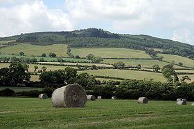
"Arklow Hill" (local name unknown) dominates the town of Arklow to the south and is situated in the southeastern section of the Wicklow Mountains, just 2 km from the Irish Sea coast. It is a prominent feature from the N11 National primary route which passes a kilometer east of the summit.
Map of Arklow Hill, Glenteige, Co. Wicklow, Ireland
In the late 1960s and early 1970s when NET Nitrate (a chemical company) was producing fertilizer in the local factory in the Avoca valley, the letters N-E-T were spelt out in dark green on the southern slope of the hill, visible from the main road (the modern N11). This was achieved by spreading nitrogen fertilizer on meadow on the hill in the shape of the letters, which advertised the effectiveness of Nitrogen in producing vigorous growth compared to the area outside the fertilized zone. It was like a biological version of the Hollywood sign.