
Intercommunality Luys en Béarn Area 6.01 km² | Time zone CET (UTC+1) Population 217 (1999) | |
 | ||
Argelos (Argelòs in Occitan) is a French commune in the Pyrénées-Atlantiques department in the Nouvelle-Aquitaine region of south-western France.
Contents
- Map of 64450 Argelos France
- Geography
- Toponymy
- History
- Administration
- Intercommunality
- Demography
- Civil Heritage
- Religious Heritage
- Education
- References
Map of 64450 Argelos, France
Geography
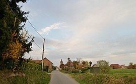
Argelos is located some 25 km north of Pau and 3 km west of Auriac. Access to the commune is by the D214 road from the village north to join the D944 road south-east of Thèze. The A65 autoroute passes through the northern tip of the commune but the nearest exit is Exit 9 near Miossens-Lanusse. The commune is mixed farmland and forest.
Located in the Drainage basin of the Adour, the Luy de France forms the north-eastern border of the commune as it flows north-west fed by its tributaries the Basta and the Balaing.
Toponymy
The commune name in béarnais is Argelos. Brigitte Jobbé-Duval indicated that Argelos probably had a latin origin of argilla (meaning "Clay") with the suffix -ossum. The meaning of the name would then be "clay soil".
The following table details the origins of the commune name and other names in the commune.
Sources:
Origins:
History
Paul Raymond noted on page 10 of his 1863 dictionary that in 1385 there were 29 fires in Argelos and it depended on the bailiwick of Pau. Auriac was formerly annexed to the commune.
The barony of Viven included Argelos, Auriac, and Viven and was a vassal of the Viscounts of Béarn.
Administration
List of Successive Mayors
(Not all data is known)
Intercommunality
Argelos is part of 4 inter-communal structures:
Demography
In 2009 the commune had 264 inhabitants. The evolution of the number of inhabitants is known from the population censuses conducted in the commune since 1793. From the 21st century, a census of communes with fewer than 10,000 inhabitants is held every five years, unlike larger towns that have a sample survey every year.
Sources : Ldh/EHESS/Cassini until 1962, INSEE database from 1968 (population without double counting and municipal population from 2006)
Argelos is part of the urban area of Pau.
Civil Heritage
The commune has several buildings and sites that are registered as historical monuments:
Religious Heritage
The Parish Church of Saint-André (12th century) is registered as an historical monument. It contains many items which are registered as historical objects:
Education
Argelos has a primary school which is shared with Astis as an inter-communal educational grouping.