
Parent range Ahr Hills (Ahr Eifel) Elevation 624 m | Mountain type Basaltvolcano Range Ahr Hills (Ahr Eifel) | |
 | ||
Similar Scharteberg, Hoher List, Dietzenley, Nerother Kopf, Kalvarienberg | ||
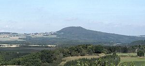
The Aremberg is, at 623 m above sea level (NN), the highest mountain in the Ahr Hills (German: Ahrgebirge) or Ahr Eifel (Ahreifel). It lies in the district of Ahrweiler, Rhineland-Palatinate (Germany).
Contents
- Map of Aremberg 53533 Aremberg Germany
- Geographic locationEdit
- Aremberg CastleEdit
- Nrburgring NordschleifeEdit
- References
Map of Aremberg, 53533 Aremberg, Germany
Geographic locationEdit
This former Tertiary volcano rises in the northwestern part of the state of Rhineland-Palatinate, around 2.25 kilometres (1.40 mi) east of its border with North Rhine-Westphalia and belongs to the volcanic region of the High Eifel. On its southwestern slopes lies the village of Aremberg and, at its southeastern foot, the village of Antweiler. The basalt cone is surrounded by the small nature reserve of Aremberg.
A section of the middle reaches of the River Ahr flows past the Aremberg to the east; to the north an Ahr tributary, the Eichenbach, flows around the mountain.
Aremberg CastleEdit
On the summit are a few ruins belonging to Aremberg Castle, below and north of the mountaintop runs a section of Roman road.
Nürburgring NordschleifeEdit
A section of the Nürburgring-Nordschleife racing track, from which the Aremberg can be seen, is named after the mountain.