
Population 748 (2006 census) Local time Tuesday 4:22 AM | Postcode(s) 4378 Postal code 4378 | |
 | ||
Location 212 km (132 mi) SW of Brisbane135 km (84 mi) S of Toowoomba53 km (33 mi) S of Warwick5 km (3 mi) N of Stanthorpe Weather 13°C, Wind E at 13 km/h, 94% Humidity | ||
Applethorpe queensland
Applethorpe is a town in the Southern Downs Region of Queensland, Australia. Applethorpe is well known for the production of apples.
Contents
- Applethorpe queensland
- Map of Applethorpe QLD 4378 Australia
- History
- Geography
- Climate
- Demographics
- Amenities
- References
Map of Applethorpe QLD 4378, Australia
History
The area was originally called Roessler after an early German settler, but the name was changed to Applethorpe (reflecting the apple orchards in the district) in 1915, as part of the anti-German sentiment during World War I.
In 1910, the establishment of the Four Mile Stanthorpe School was given and the school was opened on 14 September 1911. However, from November 1911 to November 1916, it was called Roesseller State School. However, like the town itself, the school name was changed to Applethorpe State School due to the anti-German sentiment during World War 1.
Applethorpe Post Office opened around 1919 (a receiving office had been open since 1916) and closed in 1991.
Geography
The town is positioned on the New England Highway just north of Stanthorpe in the Granite Belt region at an elevation of 872 meters (2,861 ft).
Climate
During a cold snap in 2007, the town recorded a minimum temperature of −7.7 °C. In July 2010, Applethorpe recorded a minimum of 13.6 °C which was the highest minimum on record ever for that month.
Demographics
In 2006, Applethorpe had a population of 748; of which, 20% worked in the farming or produce industries.
Amenities
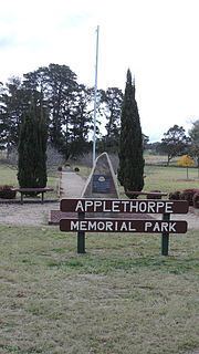
The Applethorpe Memorial Park on Ann Street commemorates those who served in defence of Australia.