
Country Russia | ||
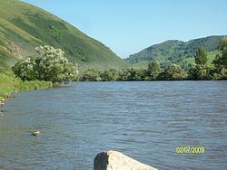 | ||
The Anuy River (Russian: река́ Ану́й) is a 327-kilometre (203 mi) long left tributary of the Ob River originating in the Altai mountains of Siberia, Russia.
Map of r. Anuy, Altai Krai, Russia
The Chyorny Anuy and the smaller Bely Anuy join to form the Anuy river. The Chyorny Anuy starts at an elevation of 1,220 metres (4,000 ft) at the southeastern end of the Anuy mountain range in the Altai Republic. Flowing in a northwestern direction, it enters Altai Krai after about 40 kilometres (25 mi). The two rivers join near Soloneshensky District.
The Anuy River exits the Altai mountains at an elevation of 250 metres (820 ft) and flows in a northeastern to eastern direction. Near the village of Anuyskoye, the river takes a northern direction and joins the Ob River near Biysk at an elevation of about 150 metres (490 ft).
The drainage basin of the Anuy River encompasses about 6,930 square kilometres (2,680 sq mi).
The average flow at Staro-Tirishkino, about 10 kilometres (6 mi) near the river's end, is about 36.1 cubic metres per second (1,270 cu ft/s) with a minimum of 6.9 cubic metres per second (240 cu ft/s) in February and a maximum of 123 cubic metres per second (4,300 cu ft/s) in April.
The Anyuy River is frozen between November and April. It is not navigable.
The Denisova Cave is approximately 28 metres (92 ft) above the right bank of the Anuy River.