
Country United States County Franklin Time zone Eastern (EST) (UTC-5) Population 14,893 (2010) | State Pennsylvania Settled 1741 Area code(s) 717 Local time Sunday 4:01 PM | |
 | ||
Weather 6°C, Wind NW at 21 km/h, 37% Humidity Points of interest Fun Castle‑GoKarts, Antrim Township Communi, Martin's Mill Covered, Enoch Brown Memorial | ||
Antrim Township is a township in Franklin County, Pennsylvania, United States. The population was 14,893 at the 2010 census, up from 12,504 at the 2000 census. It was named after County Antrim in Northern Ireland.
Contents
Map of Antrim Township, PA, USA
History
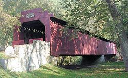
The Martin's Mill Covered Bridge, Old Brown's Mill School, Spring Grove Farm and Distillery, and Stover-Winger Farm are listed on the National Register of Historic Places.
Geography
Antrim Township lies along the southern edge of Franklin County, bordered to the south by Washington County in Maryland. The township surrounds the borough of Greencastle, a separate municipality. The unincorporated community of State Line sits along the southern edge of the township. Other unincorporated communities in the township include Bushtown, Coseytown, Worleytown, Milnor, Johnston, Kauffman, Browns Mills, Clay Hill, Shady Grove, Waynecastle, and Wingerton.
U.S. Route 11 and Interstate 81 cross the township, leading north to Chambersburg, the county seat, and south to Hagerstown, Maryland. I-81 has three exits (numbers 1, 3, and 5) in the township. Pennsylvania Route 16 runs at right angles to the other two highways, leading east to Waynesboro and west to Mercersburg.
According to the United States Census Bureau, the township has a total area of 70.3 square miles (182.1 km2), of which 70.2 square miles (181.9 km2) is land and 0.1 square miles (0.2 km2), or 0.10%, is water. Conococheague Creek, a south-flowing tributary of the Potomac River, forms the western boundary of the township in two places.
Demographics
As of the census of 2000, there were 12,504 people, 4,472 households, and 3,640 families residing in the township. The population density was 178.5 people per square mile (68.9/km²). There were 4,598 housing units at an average density of 65.6/sq mi (25.3/km²). The racial makeup of the township was 97.91% White, 0.78% African American, 0.25% Native American, 0.29% Asian, 0.24% from other races, and 0.54% from two or more races. Hispanic or Latino of any race were 0.78% of the population.
There were 4,472 households, out of which 38.3% had children under the age of 18 living with them, 71.9% were married couples living together, 5.9% had a female householder with no husband present, and 18.6% were non-families. 15.1% of all households were made up of individuals, and 5.6% had someone living alone who was 65 years of age or older. The average household size was 2.79 and the average family size was 3.10.
In the township the population was spread out, with 27.6% under the age of 18, 6.9% from 18 to 24, 31.2% from 25 to 44, 23.9% from 45 to 64, and 10.4% who were 65 years of age or older. The median age was 36 years. For every 100 females, there were 98.9 males. For every 100 females age 18 and over, there were 96.9 males.
The median income for a household in the township was $46,050, and the median income for a family was $49,632. Males had a median income of $34,884 versus $22,035 for females. The per capita income for the township was $18,590. About 4.1% of families and 4.1% of the population were below the poverty line, including 4.7% of those under age 18 and 6.4% of those age 65 or over.