
Country India District Guntur Time zone IST (UTC+5:30) Area 11.7 km² Population 16,000 (2011) Local time Monday 9:20 PM | State Andhra Pradesh Mandal Amaravati PIN 522 020 Elevation 38 m Area code 08645 | |
 | ||
Weather 27°C, Wind S at 8 km/h, 73% Humidity | ||
Amaravathi is a famous Buddhist site and village in Guntur district of the Indian state of Andhra Pradesh. It is located in Amaravati mandal of Guntur revenue division, on the banks of Krishna river.
Contents
- Map of Amaravathi Andhra Pradesh 522020
- Etymology
- History
- The stpa or mahcaitya
- Geography
- Demographics
- Culture
- Transport
- Education
- References
Map of Amaravathi, Andhra Pradesh 522020
The Buddhist site gives its name to the new capital of Andhra Pradesh, Amaravathi (spelled the same in Telugu), which is also a part of Andhra Pradesh Capital Region, but is 35 miles west of the Buddhist site at Uddandarayunipalem.
Although now it is officially designated as a village administered by a gram panchayat, it is an important historic town, and served as the capital of the Satavahana kingdom in ancient days. Sri Amaralingeswara Swamy temple is located at the Amararama Pancharama Kshetra site in this village, which makes it a holy town for the Hindus. It is also a historic Buddhist site, and the Amaravati Mahachaitya stupa was built here between the 2nd century BCE and the 3rd century CE. Designated as a historic site by the Government of India, Amaravati has been chosen as one of the sites for Heritage City Development and Augmentation Yojana (HRIDAY) scheme of Government of India.
Etymology
Amaravathi translates to The town which lives on forever in the Telugu language. It is located on the banks of river krishna .It is also referred as Amareswaram, for its famous Amareswara temple dedicated to Lord Siva, one of the famous Pancharamas.
History
The recorded history of Amaravati and nearby Dharanikota dates to 5th century BCE. It was the capital of Satavahanas who ruled from 3rd century BCE to 3rd century CE. After the decline of Satavahanas, Andhra Ikshvakus and later Pallava kings ruled Krishna river valley. Subsequently, Eastern Chalukyas and Telugu Cholas held sway over the region. Kota Kings were in control of Amaravati during the medieval times. Kota kings were subdued by Kakatiyas in 11th century CE and Amaravati became part of the unified Telugu empire. The Skanda Purana gives a picture of the place and the Siva temple located here.
Amaravati was part of Delhi Sultanate, Musunuri Nayaks, Bahmani Sultanate, Vijayanagara Empire, Sultanate of Golconda and Mughal Empire successively before the founding of the Nizam of Hyderabad in 1724. It was ceded to France in 1750 but was captured by England in 1759. Guntur returned to the Nizamate in 1768 but was ceded to England again in 1788. It was briefly occupied by Hyder Ali. It was part of Madras Presidency during the British colonial period.
The stūpa or mahācaitya
The most important historic monument in Amaravathi village is the Mahachaitya. It is protected by the Archaeological Survey of India which maintains a site museum beside the ruins.
Geography
The city is located at 16°34′N 80°22′E on the south bank of Krishna river.
Demographics
As of 2011 Census of India, the town had a population of 13,400 with 3,316 households. The total population constitute, 6,432 males and 6,958 females —a sex ratio of 1,082 females per 1,000 males. 1,321 children are in the age group of 0–6 years, of which 647 are boys and 674 are girls —a ratio of 1,042 per 1,000. The average literacy rate stands at 71.34% with 8,617 literates, higher than the state average of 67.41%.
Culture
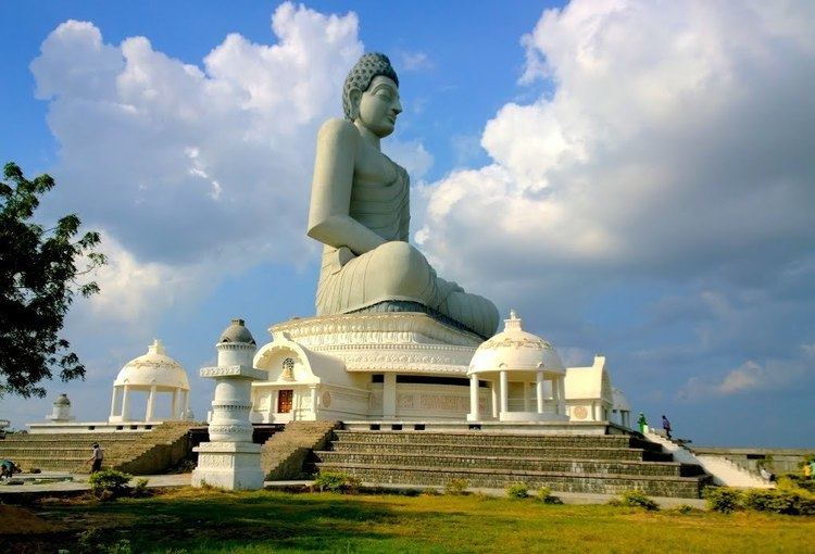
The town is a centre of pilgrimage to both Hindus and Buddhists. The inscriptions on the walls of the Amareswara temple depicts the reign of Vasireddy Venkatadri Nayudu who ruled before the advent of the British rule. He was well known for his benevolence, munificence and for the construction of a large number of temples and education centres in the Krishna river delta. It also hosts 125 ft tallest Buddhist statue in India. The ancient structures and replicas can be found at Kalachakra museum, renamed as Amaravati Heritage Centre and Museum.
The people speak Telugu. The common traditional clothing for women is a Saree and for men a Panche or a Lungi and Uttariyam. The town was given a hagiographic portrayal in the famous short story series Amaravati Kathalu by Satyam Sankaramanchi. The stories describe the contemporary culture of local people during the reign of Vasireddy Venkatadri Nayudu and also post-independent times.
The main Hindu festivals celebrated are Mahasivaratri and the Navaratri. The 30th Kalachakra festival, a popular Buddhist ritual was held at Amaravati in the first week of January 2006. It is the home for the oldest tourist places for Buddhists.
Transport
Amaravati has road connectivity and no rail network. Vijayawada–Amaravati Road connects the village with city of Vijayawada, Andhra Pradesh capital city areas of Undavalli, Penumaka, Rayapudi. While, the Guntur–Amaravathi Road connects it with the district headquarters, Guntur. It also has road connectivity from Sattenapalle, Mangalagiri and Krosuru. APSRTC operates buses from major bus stations like, NTR bus station of Guntur and Pandit Nehru bus station of Vijayawada. The village has no rail connectivity.
A waterway categorised as class–III is planned from Pulichintala to Prakasam Barrage, which connects the nearby villages of Harishchandrapuram and Vykuntapuram.
Education
The town plays a major role in education for the rural students of the nearby villages.The primary and secondary school education is imparted by government, aided and private schools, under the School Education Department of the state. As per the school information report for the academic year 2015–16, the town has more than 3,543 students enrolled in over 16 schools.