
Listing Corbett, Marilyn OS grid NH073143 Prominence 231 m Parent range Northwest Highlands | Translation The Byre (Gaelic) Elevation 798 m Mountain range Northwest Highlands | |
 | ||
Pronunciation Scottish Gaelic: [əm ˈpaːhax] Topo map OS Landranger 33, OS Explorer 414 Similar Ciste Dhubh, Aonach Meadhoin, A' Chràlaig, Mullach Fraoch‑choire, Sgùrr a' Bhealaich Dheirg | ||
Am Bàthach is a Scottish mountain situated at the head of Glen Shiel, at the western end of Loch Cluanie some 38 kilometres south east of Kyle of Lochalsh.
Contents
Map of Am Bathach, Inverness, UK
OverviewEdit
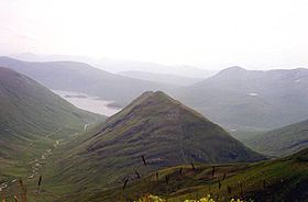
Am Bàthach reaches a height of 798 metres (2618 feet) and is a lone Corbett surrounded by considerably higher Munros, its grassy slopes are in marked contrast to the rockier peaks of the other Glen Shiel hills. it is often climbed along with the adjoining Munro of Ciste Dhubh with the route over Am Bàthach providing a more interesting and drier route to the Munro than the boggy An Caorann Beag glen. The hill offers an interesting half day walk when ascended on its own and it is frequently the only one of the Kintail mountains in the clear when weather conditions are poor. Am Bàthach’s roof like shape made up of a long NE-SW ridge with steep sides is alleged to resemble a cow shed or a byre and that is the meaning of its translated name, a throwback to the time when cattle where a prominent feature of the Scottish Highlands.
GeographyEdit
Am Bàthach’s summit ridge is roughly one km in length with the highest point lying at the northern extremity, the southern end of the ridge has a spot height of 734 metres, there is a col with a height of 705 metres at the midpoint in between the two high points. The steep slopes on either side of the mountain drop down to the valleys of the An Caorann Beag on its west side and the An Caorann Mòr on the eastern flanks, both these hillsides are seamed with numerous small streams. The southern ridge of Am Bàthach descends to the A87 road as it passes along the northern shore of Loch Cluanie and has been planted with coniferous woodland on its lower slopes, this plantation is an outlying eastern section of the Glenshiel Forest.
The hills northern flank descends by a NW ridge down to the Bealach a’ Chòinich (Pass of the Bog) with a height of 591 metres. The pass, which lives up to its name connects to the two Munros of Ciste Dhubh and Aonach Meadhoin and has a small lochan lying on it. Am Bàthach is drained by the Allt a’ Chaorainn Bhig and the Allt a’ Chaorainn Mhòir, the two burns which flow down the glens to the east and west of the hill. They flow to Loch Cluanie and reach the east coast of Scotland at the Moray Firth, some 70 km distant, via Glenmoriston and Loch Ness.
AscentsEdit
There is really only one route of ascent for Am Bàthach, this is the climb from the A87 road to the south. The only alternative is passing over the hill when descending from the Munro of Ciste Dhubh. The route from the A87 starts at the car park next to the Cluanie Inn (grid reference NH075117). From here the southern ridge of Am Bàthach can be accessed by walking east for 1.5 km along the A87 and then following an old stalkers path which leaves the road and goes to the right of the plantation to climb the southern ridge of the mountain to the summit. The summit is a good place to admire the surrounding Munros of Kintail, Loch Cluanie is well seen to the south and the Cluanie Inn is in view at its west end.