
Country Turkey Province Ankara Postal code 06xxx Area 175 km² Area code 0312 | Region Central Anatolia Time zone EET (UTC+2) Licence plate 06 Elevation 850 m | |
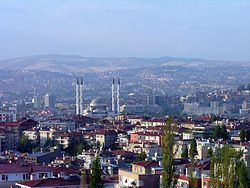 | ||
Altındağ is a metropolitan district of Ankara Province in the Central Anatolia region of Turkey, part of the city of Ankara. According to the 2000 census, the population of the district is 407,101, of which 400,023 live in the urban center of Altındağ. The district covers an area of 175 km2 (68 sq mi), and the average elevation is 850 m (2,789 ft).
Contents
- Map of AltC4B1ndaC49F Turkey
- Neighbourhoods
- Geography
- History
- Prominent neighbourhoods
- Places of interest
- References
Map of Alt%C4%B1nda%C4%9F, Turkey
Neighbourhoods
There are 26 neighbourhoods in Altındağ as of 2017.
Geography
Located just outside the city centre, (beyond the district of Ulus as far as the large Altınpark), this hillside has long been home to the workers in the city of Ankara but Altındağ remains one of the poorer quarters of the capital. The hillside is covered with illegally built gecekondu housing, home to low-income families. Among the housing there are some municipal buildings, public housing, state housing for civil servants and lots of small workshops doing car repairs and other light mechanical work.
The ancient Ankara Castle is in Altındağ and there has recently been investment in restoration work. With this architectural heritage, Altındağ is a member of the Norwich-based European Association of Historic Towns and Regions.
History
Altındağ includes parts of the historic city of Ankara, as well as the first National Assembly in which Republic of Turkey was founded is in Ulus.
Altındağ was the location of one of the first gecekondu developments in Turkey, when in the 1950s and 1960s people illegally built small, one-bedroom houses on small plots of land; then in the 1970s and 1980s these plots of land were made legal through amnesty legislation, and eventually sold to developers who replaced these shacks with larger, multi-story apartment buildings.