
Location Nordland, Norway Width 8 km (5 mi) Highest point Botnkrona Elevation 1,072 m Municipalities Alstahaug, Leirfjord | Length 30 km (19 mi) Highest elevation 1,072 m (3,517 ft) County Nordland Area 153 km² | |
 | ||
Points of interest Petter Dass‑museet, De syv søstre, MKB 1/510 Sandnessjöen | ||
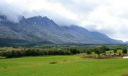
Alsten or Alsta is an island in the municipalities of Alstahaug and Leirfjord in Nordland county, Norway. The Vefsnfjorden is off the east coast, the Leirfjorden off the north coast, and the Alstenfjorden passes the south and west coast. The eastern part of the island is dominated by the Seven Sisters mountain range which has five mountains that are more than 1,000 metres (3,300 ft) tall, while the western part of the island is relatively flat and it is the location of the town of Sandnessjøen and the village of Søvika in the south.
The 30-kilometre (19 mi) long island has an area of 153 square kilometres (59 sq mi), and its highest point is the mountain Botnkrona, which reaches 1,072 metres (3,517 ft) above sea level.
The island is connected to the mainland by the Helgeland Bridge on Norwegian County Road 17, which connects the northern part of the island to the municipality of Leirfjord on the mainland. This same highway 17 continues across the island from north to south where it then connects by bridge to the nearby islands of Offersøya and Tjøtta.
The eastern part of the island is often called the "backside" of the island since it is on the other side of the mountains from the more populous side. This "backside" lies inside the municipality of Leirfjord and the Sundøy Bridge connects the Sundøy village area on the backside of the island to the mainland.