
Subregion Beira Interior Norte Population 7,242 (2011) | Region Centro Parishes 16 Area 518 km² Local time Sunday 4:37 PM | |
 | ||
Weather 12°C, Wind W at 11 km/h, 70% Humidity Points of interest Praça Alta, Picadeiro Del´Rey, Largo 25 de Abril, Quartel das Esquadras | ||
Almeida ([ɐɫˈmɐjðɐ]) is a fortified village and a municipality in the sub-region of Beira Interior Norte and the District of Guarda, Portugal. The town proper has a population of 1,300 people (2011). The municipality population in 2011 was 7,242, in an area of 517.98 square kilometres (199.99 square miles). It is located in Riba-Côa river valley. The present Mayor is António Baptista Ribeiro, elected by the Social Democratic Party. The municipal holiday is July 2.
Contents
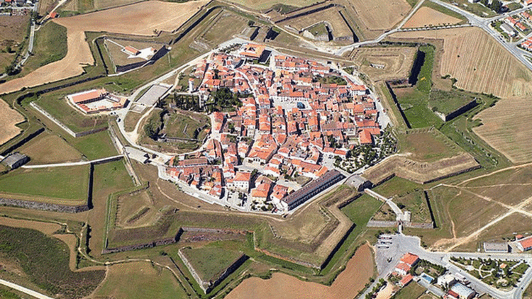
- Map of Almeida Portugal
- Location
- Twin town
- History
- Sancho I The Populator
- Spanish occupation
- Almeida Castle
- Parishes
- References
Map of Almeida, Portugal
Location
The village lies 7.2 kilometres (4.5 miles) west of the border with Spain and straddles the N332 road. The Rio Côa run northwards a short distance to the west of the village. The town's castle fortress was completed in 1641 and is located to the north of the village and is approached through the two tunnel gates and dry moat named the Portas de São Francisco.
Twin town
History
In and around the environment of Almeida, evidence of Human occupation can be found back to the Bronze Age and Iron Age. Evidence has also been found of Roman occupation followed by the Suevi and the Visigoths. The first fortification constructed in the settlement were constructed by the Muslims who occupied the village until Christian reconquest of the Iberian Peninsula. It was during this time that the current name was first used, in the form of the Arabic al-Ma'ida ('the plateau').
Sancho I, The Populator
The village of Almeida was captured from the Moors by the second king of Portugal, Sancho I in the 12th century because of its strategic position on the new country of Portugal's border with Spain. So important to the security of the country, Sancho had the village heavily fortified. The castle was refortified on three further occasions by King Dinis, King Manuel I and by King João VI. The present 12 pointed star fortification was constructed in 1641 to a Vaubanesque plan on which the French military engineer is believed to have personally worked, during the castle's final stages of completion.
Spanish occupation
During the Seven Years' War (1754 to 1763) which involved most of the great powers of Europe, Spain with the help of France launched an attack on Portugal due to its alliance with Great Britain. As a result of the invasion Almeida was captured by Spain in 1762.
Almeida Castle
The fortress around the town guards an important cross-border road from Spain, and underwent several sieges. The siege of 1810, during the Peninsular War, ended spectacularly when a chance shell ignited the main gunpowder magazine, which exploded, killing 500 defenders and destroying most of the town.
Parishes
Administratively, the municipality is divided into 16 civil parishes (freguesias):