
Admin. region Tübingen Time zone CET/CEST (UTC+1/+2) Area 45.9 km² Postal code 89604 Administrative region Tübingen | District Alb-Donau-Kreis Postal codes 89604 Population 4,533 (31 Dec 2008) Local time Sunday 2:46 PM | |
 | ||
Weather 10°C, Wind SW at 16 km/h, 48% Humidity | ||
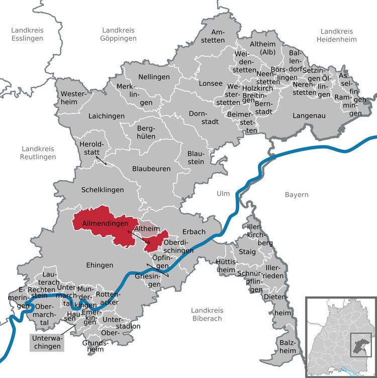
Allmendingen is a municipality in the Alb-Donau district, in Baden-Württemberg, Germany.
Contents
- Map of 89604 Allmendingen Germany
- Geography
- Neighboring communities
- Municipality arrangement
- History
- Population Development
- Politics
- Crest
- Transportation
- Established businesses
- Leisure and sports facilities
- Incorporations
- Renovation of the center
- Buildings
- Notable people
- References
Map of 89604 Allmendingen, Germany
Geography
Allmendingen is located on the Schmiech in an originally from the Danube eroded valley that separates the easter Hochsträß from the rest of the Swabian Jura. The highest point on the Lutheran mountains (Ennahofen) is 750 meters above sea level. NN.
Neighboring communities
The municipality is bordered to the north to Schelklingen, in the east to Altheim, in the south and west to Ehingen (Donau).
Municipality arrangement
The municipality Allmendingen consists of the locations Allmendingen (3304 inhabitants on 30 April 2009) ), Ennahofen (266 inhabitants), Grötzingen (296 inhabitants), Niederhofen (375 inhabitants) and Weilersteußlingen (249 inhabitants).
History
Earliest evidence of human habitation is the discovery of a brick kiln dating back to the Roman occupation in the district Niederhofen.
Population Development
There are numbers of inhabitants after the respective area of jurisdiction. The figures are census results (¹) or official updates of the Statistical Office of Baden-Württemberg.
Politics
The council Allmendingen has after the last elections 20 members. The local elections on 25 May 2014 led to the following official results. The turnout was 58.5%. The council consists of the elected honorary councilors and the mayor as chairman. The mayor is entitled to vote in the municipal council.
Crest
Blazon : In silver under a blue shield head, within three gold balls (loaves), a black, upright horse with a red tongue. The coat of arms combines elements of the coat of arms of the lords of Freyberg (balls), whose history is closely linked to the Allmendingen, and the bourgeois family Renner (horse), which also had possessions in Allmendingen.
Transportation
Allmendingen is located on the Danube Valley Railway from Donaueschingen to Ulm and is a regional train stop. There are hourly rail connections to Ehingen (Donau) and Ulm. Allmendingen is incorporated in the Donau-Iller-Nahverkehrsverbund. The community is located at the national road B 492 Ehingen-Blaubeuren.
Established businesses
The largest employer is the automotive Burgmaier. Other industrial companies are the form manufacturers Rampf, as well as the cement plant Schwenk.
Leisure and sports facilities
Allmendingen has an outdoor pool. There is also a tennis court, a gymnastics and sports hall and the football stadium of the TSV Allmendingen.
Incorporations
On January 1, 1974, the previously independent municipalities Ennahofen, Grötzingen, Niederhofen and Weilersteußlingen were incorporated.
Renovation of the center
The municipality Allmendingen leads since 2000 through a restructuring of their village. Within the rehabilitation section I the old school house, built in 1885, was transformed into a community center. The following public construction phases were realized: