
Highest point Mount Paget | Mountains Mount Paget | |
 | ||
Countries South Georgia and the South Sandwich Islands, Falkland Islands (Islas Malvinas) Similar Mount Paget, Mount Belinda, Ocean Harbour, Husvik, South Georgia Museum | ||
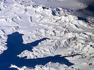
The Allardyce Range is a mountain range rising south of Cumberland Bay and dominating the central part of South Georgia, a UK overseas territory. It extends for 50 km from Mount Globus in the northwest to Mount Brooker in the southeast, with peaks of 2000 to 2935 m and including Mount Paget (2,935m) the highest peak of the range and also the highest point in the UK territory. Other peaks of the range include Mount Roots.
Map of Allardyce Range, SIQQ 1ZZ, South Georgia and the South Sandwich Islands
Although not shown on the charts of South Georgia by Cook in 1775 or Bellingshausen in 1819, peaks of this range were doubtless seen by those explorers. The range was named c. 1915 after Sir William Lamond Allardyce (1861–1930), Governor of the Falkland Islands and Dependencies, 1904–14.
References
Allardyce Range Wikipedia(Text) CC BY-SA