
Languages spoken Hindi, Hinglish Area 3,747 km2 | State Uttar Pradesh District Aligarh Founded koil-Dor Rajputs; Aligarh-Nafaz Khan | |
Colleges and Universities Aligarh Muslim University, Zakir Hussain College of Engineering and Technology, Mangalayatan University | ||
The city of Aligarh (formerly Allygurh) is the administrative headquarters for Aligarh Division Aligarh district and Aligarh Police Range, in the Northern Indian state of Uttar Pradesh and 126 miles (291 km) north-west of Kanpur. It is notable for being the seat of Aligarh Muslim University. The city is nicknamed Tala Nagri, ("City of Locks") for its famous Lock industry. Aligarh is located approximately 90 miles (140 km) south-east of the capital city of New Delhi. Aligarh is one out of 13 Metro Cities in UP: Agra, Aligarh, Allahabad, Bareily, Gorakhpur, Ghaziabad, Kanpur, Lucknow, Moradabad, Merrut, Varanasi, Jhansi,Saharanpur in Uttar Pradesh. Aligarh is the 55th largest city in India.
Contents
- Map of Aligarh Uttar Pradesh
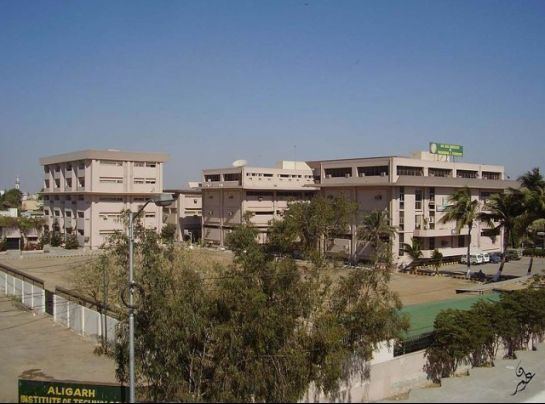
- View of aligarh city uttar pradesh
- History
- Geography
- Economy
- Culture folk music
- References
Map of Aligarh, Uttar Pradesh
View of aligarh city uttar pradesh
History
The historian Thakur Deshraj has mentioned that the people of Kampilya were later known as Koil. The Koil people came from Kampilya and founded the city known as Kampilgarh, situated south east of Ganges. The town of Kampilgarh later became popular as Koil which is now Aligarh. Before the 18th century, Aligarh was known as Kol or Koil.caste, the name of a place or mountain and the name of a sage or demon. Study of the place-name indicates that the district was once fairly well covered by forests and groves. The history of the district through the 12th century AD is obscure.

According to Edwin T. Atkinson, the name Kol was given to the city by Balarama, who slew the great Asura (demon) Kol there and, with the assistance of the Ahirs, subdued this part of the doab. In another account, Atkinson points out a "legend" that Kol was founded by the Dor tribe of Rajputs in 372 AD. This is further confirmed by an old fort, the ruined Dor fortress, which lies at the city centre.
Some time before the Muslim invasion, Kol was held by the Dor Rajputs. In the time of Mahmud of Ghazni, the chief of the Dors was Hardatta of Baran. Statues of Buddha and other Buddhist remains have been found in excavations where the citadel of Koil stood, indicating a Buddhist influence. Hindu remains indicate that the citadel probably had a Hindu temple after the Buddhist temple.
In 1194 AD, Qutb-ud-din Aibak marched from Delhi to Kol, "one of the most celebrated fortresses of Hind". Qutb-ud-din Aibak appointed Hisam-ud-din Ulbak as the first Muslim governor of Koil.
Koil is also mentioned in Ibn Battutas Rihla, when Ibn Battuta along with 15 ambassadors representing Ukhaantu Khan, the Mongol Emperor of the Yuan dynasty in China, travelled to Kol city en route to the coast at Cambay (in Gujarat) in 1341. According to Ibn Battuta, it would appear that the district was then in a very disturbed state since the escort of the Emperors embassy had to assist in relieving Jalali from an attacking body of Hindus and lost an officer in the fight. Ibn Batuta calls Kol "a fine town surrounded by mango groves". From these same groves the environs of Kol would appear to have acquired the name of Sabzabad or "the green country".
In the reign of Akbar, Kol was made a Sirkar and included the dasturs of Marahra, Kol ba Haveli, Thana Farida and Akbarabad. Both Akbar and Jahangir visited Kol on hunting expeditions. Jahangir clearly mentions the forest of Kol, where he killed wolves.
During the time of Ibrahim Lodhi, Muhammad, son of Umar, was the governor of Kol. He built a fort at Kol and named the city Muhammadgarh, after himself, in 1524–25. Sabit Khan, who was then the governor of this region, of Farrukh Siyar and Muhammad Shah, rebuilt the old Lodhi fort and named the town after himself: Sabitgarh.
The Jat ruler, Surajmal, with help from Jai Singh of Jaipur and the Muslim army, occupied the fort of Koil. Koil was renamed Ramgarh and finally, when a Shia commander, Najaf Khan, captured it, he gave it its present name of Aligarh. Aligarh Fort (also called Aligarh Qila), as it stands today, was built by French engineers under the command of French officers Benoit de Boigne and Perron.
Geography
Aligarh is located at the coordinates 27.88°N 78.08°E? / 27.88; 78.08. It has an elevation of approximately 178 metres (587 feet). The city is in the middle portion of the doab, the land between the Ganges and the Yamuna rivers. The G.T. Road passes through.
Economy
The city is an agricultural trade centre. Agricultural product processing and manufacturing are important.
Culture & folk music
A various styles in music and art in folk songs of North Indias Braj region includes are-