
Width 18–22 km (11–14 mi) Elevation 800 m | Length 30.5 km (18.95 mi) Highest elevation 800 m (2,600 ft) Region Qikiqtaaluk Area 267 km² | |
 | ||
Island group Canadian Arctic Archipelago | ||
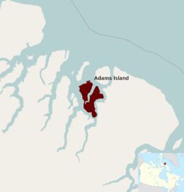
Adams Island (Inuit: Tuujjuk) is an uninhabited island in the Qikiqtaaluk Region of Nunavut, Canada. The island is located in Baffin Bay off the northeastern coast of Baffin Island in the Canadian Arctic Archipelago. Nearby are Dexterity Island (northeast), Dexterity Fiord and Baffin Island (east), Tromso Fiord (south), Paterson Inlet (west), Bergesen Island (northwest), and Isbjorn Strait (north).
Map of Adams Island, Baffin, Unorganized, NU, Canada
Adams Island is irregularly shaped, its eastern and western sides split by the Ratcliffe Arm. Coastlines slope sharply while the interior mountains are over 800 m (2,600 ft) in height. The island comprises an area of 267 km2 (103 sq mi), measuring 30.55 kilometres (18.98 mi) in length and 18 kilometres (11 mi) to 22 kilometres (14 mi) in width.
Another, much smaller, Adams Island is located off the northeastern tip of Baffin Island.