
Area 214.4 km² | Phone number 0265-43-2220 Population 6,578 (Oct 2016) Local time Wednesday 5:21 PM | |
 | ||
Weather 3°C, Wind E at 3 km/h, 98% Humidity Points of interest Heavens Sonohara, Achi Shrine, Jibusaka Pass | ||
Achi (阿智村, Achi-mura) is a village located in Shimoina District in far southwestern Nagano Prefecture, in the Chūbu region of Japan. As of 1 October 2016, the village had an estimated population of 6,578 and a population density of 30.7 persons per km². Its total area was 214.43 square kilometres (82.79 sq mi).
Contents
- Map of Achi Shimoina District Nagano Prefecture Japan
- Geography
- Surrounding municipalities
- History
- Economy
- Education
- Railway
- Highway
- Noted people from Achi
- References
Map of Achi, Shimoina District, Nagano Prefecture, Japan
Geography
Achi is located in mountainous far southwestern Nagano Prefecture, bordered by Gifu Prefecture to the west. Mount Ena (2191 meters) is on the border of the village with Gifu Prefecture
Surrounding municipalities
History
The area of present-day Achi was part of ancient Shinano Province. The modern villages of Ochi, Chiri and Goka were established on April 1, 1889 by the establishment of the municipalities system. The three villages merged on September 30, 1956 to form the village of Achi. The neighboring village of Namiai was annexed on January 1, 2006.
On March 31, 2009 the village of Seinaiji, also in Shimoina District, was merged into Achi.
Economy
The economy of Achi is based on agriculture, with Jerusalem artichoke, garlic and Yacón as noted local specialities
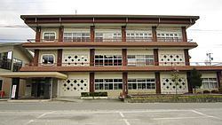
Education
Achi has five public elementary schools and one public middle school operated by the village government. The village has one public high school, which is operated by the Nagano Prefectural Board of Education.