
Width 5 km (3.1 mi) Area 133 km² | Length 36 km (22.4 mi) Highest point Mount Ṣāliḥ Population 450 Island group Socotra | |
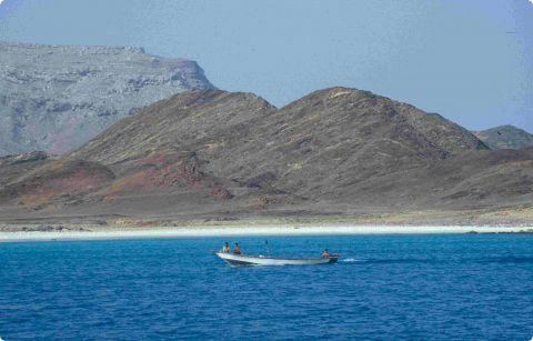 | ||
Abd al Kuri (Arabic: عبد الكوري) is a rocky island about 65 miles (105 km) southwest of Socotra in the Indian Ocean. It is part of the Socotra Archipelago and belongs to the Socotra Governorate of Yemen, although it is geographically closer to Somalia. It consists of granite and diorite covered by limestone.
Map of Abd al Kuri, Yemen
Much of Abd al Kuri is semi-desert with little vegetation. Two ranges of hills separated near the centre occupy the entire length of the island. The northern coast consists mostly of a sandy beach with a few rocky points, while the southern coast consists of steep cliffs. Its highest point, Mount Ṣāliḥ, reaches an altitude of over 700 metres (2,300 feet). Most of its inhabitants subsist on fishing. Kilmia is the main village.
Abd al Kuri has a number of endemic plant species and an endemic bird, the Abd al-Kuri sparrow with estimated population of fewer than 1,000.
On July 1, 2006, the Somali seafaring vessel Mariam IV sank off the coast of Abd al Kuri. 16 of the 19 crew members survived, and complications followed when the citizens of Kilmia would not allow the use of their own radio. Rescue by a German helicopter came a week later, but the chief officer was mistakenly left behind. Due to difficulties with wind, transportation, and communication, the officer was not returned to mainland Yemen until September. He described the island as "A hellish place, where time stands still, and one can feel completely alone in the world."