
 | ||
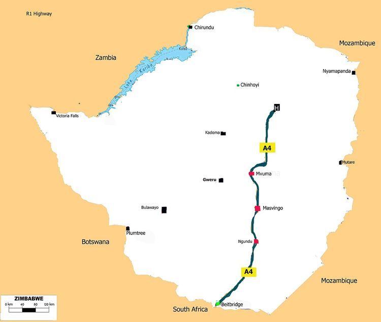
The A4 is a highway, also known as the R1 Highway runs between Beitbridge and Harare. From Beitbridge it passes through Rutenga, Ngundu, Masvingo, Mvuma, Chivhu before reaching Harare.
Contents
- Map of A4 Zimbabwe
- Pan African Highway Link
- Rehabilitation
- Waypoints
- Junctions
- R6 Highway
- R7 Highway
- P4A9 Highway
- P7A9 Highway
- P5A10 Highway
- R8 Highway
- References
Map of A4, Zimbabwe
As a national road it is known as the A4 Highway and as a regional road corridor it is known as the R1 Highway.Source: [Map 9.2 Road Transport Network of Zimbabwe.]
Pan African Highway Link
Together with the R3 Highway which runs from Harare to Chirundu, the R1 Highway is part of the North-South Corridor which is the Cairo-Cape Town Highway. (Chirundu to Beitbridge 897 kilometres. "557 miles")
The Trans-African Highway 4 is the road network, being developed with the collaboration of the African Union, the United Nations Economic Commission for Africa and the African Development Bank. Its length is about 10,228 kilometers connecting Cairo and Cape Town. This Zimbabwean route is shorter by 150 kilometres (93 mi) than the route from Zambia through Botswana to South Africa. The R1 Highway is therefore a very important link taking the Trans-African Highway from Harare to Beitbridge where is continues into South Africa as N1 Highway.
Rehabilitation
The highway is set for rehabilitation as part of the ongoing national roads project and as an important link to the Trans-African Highway.
The R1 is the most direct link between the capital cities of Harare and Pretoria, and together with the R3 provide Zambia access to the Indian Ocean ports. The road carries between 1,000 and 5,000 vehicles per day, with the heavier flows in the proximity of Harare. It is therefore proper to rehabilitate this road. The Harare-Beitbridge road is part of the trunk road network of Zimbabwe, which is a part of the North-South Corridor – one of the major arterial links in the regional road network. The road is the most direct link between the capital cities of Harare and Pretoria, and provides landlocked Zambia access to the Indian Ocean ports of Durban and Richards Bay in South Africa. "The road carries between 1000 and 5 000 vehicles per day, with the heavier flows in the proximity of Harare.
Waypoints
Major way points are
Junctions
Junctions here are in North to South; Harare to Beitbridge order. These are major junctions only (trunk roads).
R6 Highway
The R Highway also known as the Chivhu-Nyazura Highway branches east from Chivhu.
R7 Highway
R7 Highway branches west at Mvuma to Gweru. Also called A17 or Gweru-Mvuma Road
A17 Gweru-Mvuma Road
P4/A9 Highway
A9 branches east at Masvingo to Mutare via Birchnough Bridge. P4 is part of the A9 that runs from Mutare to Mbalabala.
A9 Highway starts in Mutare city center as Herbert Chitepo Street at the intersect with Robert Mugabe Avenue which is the A3 Highway to Harare. ( 18.975826°S 32.668915°E / -18.975826; 32.668915 (A9 Road, Mutare, Zimbabwe) )
At the city end Herbert Chitepo Street adopts the name Chimanimani Road.
The road begins in Mutare and goes through Nyanyadzi, Birchnough Bridge, Nyika, Masvingo, Mashava, Zvishavane, Filabusi then Mbalabala where it joins the (A6) Bulawayo-Beit Bridge Highway near the 61.5 km peg.
P7/A9 Highway
Turns right at Masvingo to Mbalabala via Mashava. It also part of the mational route called A9 that starts at Mutare and ends at Mbalabala via Masvingo. Mutare to Masvingo is primary road P4 while the Masvingo to Mbalabala part is primary road P7 but still A9 highway.
P5/A10 Highway
A10 branches east at Ngundu to Chiredzi through to Tanganda.
A10 Ngundu-Triangle-Chiredzi-Chisumbanje-Chimanimani Road
R8 Highway
R branches east at Rutanga to Sango via Mbizi