
 | ||
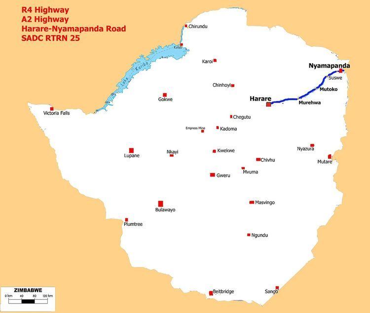
The A2 Highway ( R4 Highway ) is a primary road in Zimbabwe running from Harare to Nyamapanda at the border with Mozambique. The Mozambican side border post is called Cochemane. This is a busy entry point used by people travelling by road between South Africa, Malawi, Zimbabwe and Mozambique. It starts at intersection with Samora Machel Avenue; however Enterprise Road itself begins from the T-junction with Robert Mugabe Avenue, opposite the market in Eastlea, east of Simon Muzenda Street (Fourth Street) Road Port; a bus terminus for inter-regional buses.
Contents
The A2 Highway proper begins where Enterprise Road makes a Y junction sending out A13 Highway to the left hand side and the A2 Highway to the right or straight ahead. 17.737255°S 31.204773°E / -17.737255; 31.204773 (A2 Highway Harare end) and it ends right at the border with Mozambique. 16.96359°S 32.86133°E / -16.96359; 32.86133 (A2 Highway Nyamapanda end)
Background
The 238 km long A2 Highway is popularly known as Mutoko Road and sometimes called Nyamapanda Road.
The A2 Highway was constructed in 1980. Before 1980 the road was partly gravel towards Nyamapanda. Is one of the narrow highways in Zimbabwe. The road is part of the regional trunk road network linking Zimbabwe to the rest of the Sadc and Comesa regions through Mozambique.
Operations
The A2 Highway known as Mutoko Road, Mutoko being popular as a mango and tomato supplier to Mbare Musika the largest green market in Harare and all Zimbabwe.
The border post known as the “Nyamapande Customs Post” is located close to the town of Nyamapanda in Mashonaland East Province. The town itself was named after the Nyamapanda River. The Mozambican side is called Cochemane. In Mozambique the A2/R4 becomes Route 103 to Tete en route to Malawi.
Regional Road Corridor
As a regional corridor the A2 is known as the R4 Highway relays traffic from South Africa to Malawi. From Harare to Lilongwe using the A2/R4 Highway and Mozambique's Route 222 the distance is about 741 km (460.4 miles).
This is SADC Route 25 from Durban to Tanzania via Zimbabwe, Mozambique and Malawi and in Zimbabwe the corridor is 812 km long.
Junctions
• Kotwa. 17.00008°S 32.671974°E / -17.00008; 32.671974 (Chevecheve River)