
Magnitude 6.7 Mw Type Reverse Max. intensity VI (Strong) Date 13 June 2007 | Depth 23 km (14 mi) Areas affected Guatemala Casualties None | |
 | ||
Similar 2007 Kent earthquake, 2007 Gisborne earthquake, March 2007 Sumatra, 2007 Solomon Islands e, 2007 Tocopilla earthquake | ||
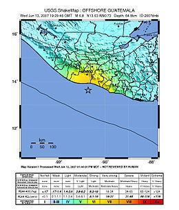
The 2007 Guatemala earthquake occurred on June 13 at 13:29:46 local time. The epicenter was located in the Pacific Ocean, south of Puerto Quetzal, about 115 kilometres (71 mi) south-southwest of Guatemala City.
The quake was reportedly felt in Guatemala, El Salvador and parts of Mexico. The quake caused a minor landslide on the Inter-American Highway, and a small number of houses were reported to have been damaged or destroyed along Guatemala's south coast, but there were no reports of major damage or casualties.
While the USGS assigned a magnitude of 6.7 for this event, many local seismological agencies in Guatemala, El Salvador and Nicaragua only registered the quake in the 5.5–6.0 range. These calculations are more accurate due to the seismographs' locations closer to the epicenter, and are in agreement with the minor shaking reported by residents.
In addition, the USGS coins all movements as earthquakes, while in Latin America, small movements such as this one are called tremors ("temblores" in Spanish).