
Max rating Damage $160.22 million | Highest winds ~200 mph (320 km/h) | |
 | ||
Formed May 22, 2004 1830 CST – 2010 CST Casualties 1 fatality, 38 injuries Areas affected Nebraska (Jefferson, Saline, Gage, Lancaster, and Otoe counties) | ||
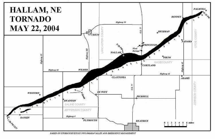
On May 22, 2004, a long-track F4 tornado formed during a tornado outbreak in a very unstable, late-day airmass and tore through multiple counties southeast Nebraska. The tornado damaged many towns along its path but primarily leveled the town of Hallam. The Hallam tornado is currently recognized by NOAA as the second-largest tornado on record, peaking at 2.5 miles (4.0 km) wide at Hallam.
Contents
Tornado sequence
The Hallam tornado formed west and northwest of Daykin at 7:30pm CDT as an F1 on the Fujita Scale (the EF scale had not been established yet in 2004). One satellite tornado, rated an F1 in intensity, formed and quickly dissipated northeast of town. The main storm turned and traveled east-northeast from Daykin, to a point south-southeast of Western and then to about 2 miles (3.2 km) north of Swanton. During this time, the tornado fluctuated between an F0/1 and intensified. The only damage reported in the area was to farmhouses and silos.
The tornado remained confined within the F0-1 range until it hit southern Wilber, where it became an F2. The damage here was slight, with only roofs blown off. The tornado continued east-northeast, grazing the east side of Wilber as it moved towards Clatonia. Here it is estimated that the tornado was an F3.
After passing just northwest of Clatonia, the tornado moved through Hallam at 8:35pm CDT, where damage reached a high-end F4 in intensity. At Hallam, the tornado was a record-breaking 2.5 miles (4.0 km) wide (the widest tornado ever recorded at the time). Most houses in Hallam were completely demolished, along with farming equipment and structures. A coal train was tossed off its tracks on the west side of town. Hallam did escaped the most intense winds of the storm though, which were to the south.
East of Hallam, the tornado was rated a F2-3 as it turned east and began to cycle. It decreased in size to just about a mile wide as it passed north of Cortland, where it turned northeast and passed 2 miles (3.2 km) north of Firth. Norris School District 160 suffered severe damage, with the middle school being hit the worst. The auditorium roof and other walls within the school caved in. Buses were tossed and homes northeast of the school were flattened.
At this point, the storm regained intensity, reaching F4 status. Damage continued northeast to Holland and to a point north-northwest of Panama. Here, tornado damage was light - F2 at best. The tornado then tracked north-northeast to Bennet, where some houses received F3 tornadic damage. At Bennet, the twister turned east-northeast and began to thin out. Damage east-northeast of Bennet was within the F0/1 scale. The tornado finally dissipated a mile west-southwest of Palmyra at 9:10pm Central Daylight Time.
Damage
The storm was long-lived, having been on the ground for more than 100 minutes. It was also a long-track tornado, covering 52 miles (84 km). Although it damaged towns and demolished many buildings, there were no damage-cost estimates available. The Hallam tornado became the widest on record until it was barely surpassed on May 31, 2013 by the El Reno, Oklahoma tornado, which had a width of 2.6 miles (4.2 km).