
Length 84 km Basin area 753 km² | Basin size 753 km (291 sq mi) Discharge 5.58 m³/s | |
 | ||
The Ūla (Belarusian: Ула) is a river in Dzūkija National Park in southern Lithuania and northern Belarus.
Map of %C5%AAla, Lithuania
Its total length is 84 km. The Ūla flows into the Merkys.
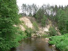
The river is mostly shallow, with colorful water foliage flowing near the surface. It has numerous bends, rocks and steep sandy shores. All of this makes Ūla one of the most beautiful rivers in Lithuania and a popular, albeit a bit difficult canoeing destination.
References
Ūla Wikipedia(Text) CC BY-SA