
Elevation 125 m | Population 1,872 Local time Sunday 9:06 PM | |
 | ||
Weather 15°C, Wind NW at 10 km/h, 61% Humidity Voivodeship | ||
Święta Katarzyna [ˈɕfjɛnta kataˈʐɨna] ("Saint Catherine", German: Kattern) is a village in Gmina Siechnice, Wrocław County, Lower Silesian Voivodeship, in south-western Poland.
Map of %C5%9Awi%C4%99ta Katarzyna, Poland
Before 1 January 2010, the district of Gmina Siechnice was called Gmina Święta Katarzyna, and Święta Katarzyna was its seat. (This was one of only two cases in Poland where a gmina contained a town but had its administrative seat in a village; the remaining one is Gmina Nowe Skalmierzyce.)
The village has a population of 1,872 (as at 2006). It lies approximately 12 kilometres (7 mi) south-east of the regional capital Wrocław. It first appears in written records in 1257 as Santa Katherine. Prior to 1945 the area was part of Germany.
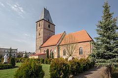
Buildings of interest include the fortified church of Saint Catherine, which dates to at least 1257, and has been rebuilt on several occasions, including in 1720 and after the Second World War. The church contains a picture of the Madonna of Częstochowa, and is considered a Marian shrine.