
- summer (DST) CEST (UTC+2) Area 15.28 km² | Elevation 471 m Local time Sunday 7:44 PM | |
 | ||
Weather 17°C, Wind N at 6 km/h, 53% Humidity | ||
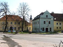
Římov (German: Rimau) is a village and municipality in the South Bohemian Region of the Czech Republic located on left bank of the Malše River about 14 km south of České Budějovice. The municipality consists of six parts: Římov, Branišovice, Dolní Stropnice, Dolní Vesce, Horní Vesce and Kladiny.
Contents
Map of %C5%98%C3%ADmov, Czechia
History
The first written mention of Římov dates from 1395.The village was founded probably in the 13th century and belonged to lower aristocratic families. In 1626 Římov became property of Duke of Eggenberg, the owner of the castle in Český Krumlov. In the same year the Duke gave Římov to the Jesuits and they established there a pilgrimage location with large Way of the Cross in 1648. The Way contains 25 stations and every year many people are starting their pilgrimage tradition right in Římov.
Římov Reservoir
On the Malše River just above the village there is a reservoir providing drinking water for large portion of Southern Bohemia. The dam, completed in 1977, is 47 m high and 290 m long at crest. It creates a reservoir with surface of 210 ha, volume of over 30 million m³ and permanent minimal output of 650 l/s.