
- Tree Katsura Local time Monday 2:29 AM | Population 9,746 (Sep 2015) | |
 | ||
Weather 1°C, Wind S at 6 km/h, 95% Humidity Points of interest Owani Hot Spring, Chausuyama Park, Ajara Park, Daienji, Jinkichimori | ||
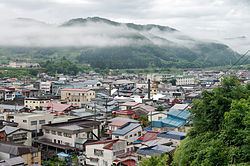
Ōwani (大鰐町, Ōwani-machi) is a town located in Minamitsugaru District of south-central Aomori Prefecture in the Tōhoku region of northern Japan. As of September 2015, the town had an estimated population of 9,746 and a population density of 59.6 persons per km². Its total area was 163.41 square kilometres (63.09 sq mi).
Contents
- Map of Owani Minamitsugaru District Aomori Prefecture Japan
- Geography
- Neighbouring municipalities
- History
- Economy
- Education
- Railway
- Highway
- Noted people from wani
- Sister cities
- References
Map of Owani, Minamitsugaru District, Aomori Prefecture, Japan
Geography
Ōwani occupies the hilly southern border between central Aomori Prefecture and northern Akita Prefecture. The town has a cold maritime climate characterized by cool short summers and long cold winters with heavy snowfall.
Neighbouring municipalities
Aomori Prefecture
Akita Prefecture
History
During the Edo period, the area around Ōwani was controlled by the Tsugaru clan of Hirosaki Domain. After the Meiji Restoration, it became a village within Minamitsugaru District of Aomori Prefecture. On April 1, 1923, Ōwani was proclaimed as a town. On July 1, 1954, it annexed neighboring Kuradate Town, but lost a portion of its territory to Hirosaki City on September 30, 1964.
Economy
The economy of Ōwani is heavily dependent on agriculture, horticulture and forestry. Tourism from ski resorts and onsen hot springs also contribute to the local economy. Mount Ajara was a venue for the 2003 Asian Winter Games).
Education
Ōwani has one elementary school and one middle school. The town's only high school, a branch of Hirosaki Minami High School, closed in 2013.