
Country Japan - Tree Chinaberry Area 6.59 km² Local time Monday 1:11 AM | District Ama - Flower Satsuki azalea Population 31,226 (May 2015) Prefecture Aichi Prefecture | |
 | ||
Region Chūbu region
Tōkai region Time zone Japan Standard Time (UTC+9) Weather 6°C, Wind NW at 14 km/h, 71% Humidity | ||
Ōharu (大治町, Ōharu-chō) is a town located in Ama District, Aichi Prefecture, Japan. As of May 2015, the town had an estimated population of 31,226 and a population density of 4740 persons per km². The total area was 6.59 square kilometres (2.54 sq mi).
Contents
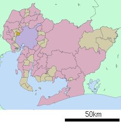
- Map of Oharu Ama District Aichi Prefecture Japan
- Geography
- Neighboring municipalities
- History
- Education
- Railway
- Highway
- References
Map of Oharu, Ama District, Aichi Prefecture, Japan
Geography
Ōharu is located in western Aichi Prefecture.
Neighboring municipalities
History
Ōharu Village was established in 1889. It was raised to town status in 1975. In 2008, discussions were held to merge Ōharu with neighboring Shippō, Jimokuji and Miwa towns. The latter three municipalities formed the new city of Ama, but Ōharu withdrew from the negotiations, and remains an independent municipality.
Education
Ōharu has three elementary and one middle school.
Railway
Ōharu is not served by any passenger rail transport. The nearest train station is Nakamura Kōen on the Nagoya Municipal Subway’s Higashiyama Line in neighboring Nakamura-ku, Nagoya.