
Arabic عكبرة Palestine grid 197/260 Local time Saturday 10:07 AM | Date of depopulation 10 May 1948 | |
 | ||
Weather 8°C, Wind SE at 3 km/h, 52% Humidity | ||
Akbara (Arabic: عكبرة) was an Arab Palestinian village. An Arab-majority village existed during Ottoman and British eras. Prior to summer 1948, there was a Palestinian Arab Muslim village, located 2.5 kilometres south of Safed, which was depopulated of original residents.
Contents
- Map of Akbara Safed Israel
- Location
- Roman era
- Middle Ages
- Ottoman era
- British Mandate era
- Israeli era
- References
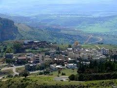
Map of Akbara, Safed, Israel
Location
The village of 'Akbara was situated 2.5 km south of Safad, along the two sides of a deep wadi that ran north-south. Southeast of the village lay Khirbat al-Uqayba, identified as the Roman village Achabare, or Acchabaron. This khirba was a populated village as late as 1904.
Roman era
The nearby khirba was excavated during the Mandate period, and was shown to contain remains such as building foundations, hewn stones, and wine presses. Cisterns have also been found. According to Josephus, the village was fortified by him during the First Jewish-Roman War. It is later mentioned in the Talmudic era under late Roman rule.
Middle Ages
Akhbara remained a Jewish village following Arab occupation of the region. The Cairo Geniza mentions a Jew from the village of Akhbara, thus supporting village's existence during Fatimid rule of 969 to 1099. By the 11th century however it appears to have been abandoned.
Ottoman era
'Akbara, was incorporated into the Ottoman Empire in 1517, and in the census of 1596 the village was part of the nahiya ("subdistrict") of Jira under the liwa' ("district") of Safad, with a population of 34 households and 1 bachelor, all Muslims. It paid taxes on a number of crops and produce, including wheat, barley, summer crops, olives, occasional revenues, goats, beehives, and a press which was either used for processing grapes or olives.
In 1875 Victor Guérin visited, and described it: "The ruins of Akbara cover a hillock whose slopes were formerly sustained by walls forming terraces; the threshing floors of an Arab village occupy the summit. Round these are grouped the remains of ancient constructions now overthrown." "The village lies on the east of the wady. It is dominated by a platform on which foundations can be traced of a rectangular enclosure called el Kuneiseh, measuring thirty paces in length by twenty-three in breadth. It stands east and west, and was firmly constructed of good cut stones. The interior is at present given up to cultivation. This enclosure seems to have been once a Christian church."
In 1881, the Palestine Exploration Fund's Survey of Western Palestine (SWP) described Akbara as a village built of stone and adobe with about 90 inhabitants who cultivated olive and fig trees.
British Mandate era
In the 1922 census of Palestine conducted by the British Mandate authorities, Akbara had a population of 147; all Muslims, increasing in the 1931 census to 275, still all Muslims, in a total of 49 houses.
During this period the village houses were made of masonry. In 1945 the population was 390, and the total land area was 3,224 dunums; 2,222 dunums was used for cereals, 199 dunums were irrigated or used for orchards, while 6 dunams were built-up (urban) land.
Israeli era
During the siege of Safad 'Akbara was targeted for occupation in line with Plan D. The Hagana attack was launched on 9 May and completed by the Palmach first battalion. It was found that many of the villagers had fled due to news of Deir Yassin and 'Ein al Zeitun, the village was then blown up and destroyed.
25 May 1948, during Operation Yiftah, under the command of Yigal Allon, Galilee was cleared of its Palestinian Arab population. The Palmach's First Battalion. Following the 25 May exodus of al-Khisas the last 55 villagers who had remained in their homes for just over a year were 'transferred' by Israeli forces despite having good relations and collaborating with Jewish settlements in the area. During the night of 5/6 June 1949, the village of al-Khisas was surrounded by trucks and the villagers were forced into the trucks ’with kicks, curses and maltreatment,’ in the words of a Mapam Knesset member, Elizer Peri, quoted by Morris: "The remaining villagers said that they had been ’forced with their hands to destroy their dwellings,’ and had been treated like ’cattle.’ They were then dumped on a bare, sun-scorched hillside near the village of ’Akbara [by then an abandoned Palestinian Arab village] where they were left ’wandering in the wilderness, thirsty and hungry.’ They lived there under inhuman conditions for years afterwards," along with the inhabitants of at least two other villages (Qaddita and al-Ja'una) expelled in similar circumstances. The expellees remained at ’Akbara for eighteen years until agreeing to resettlement in Wadi Hamam.
Salman Abu-Sitta, author of the Atlas of Palestine, estimated that the number of Palestinian refugees from 'Akbara in 1998 was 1,852 people.
Of what remains of 'Akbara's built structures, Walid Khalidi wrote in 1992 that, "The original inhabitants of the village were replaced by "internal" refugees from Qaddita villages several kilometers north of Safad. Since 1980, however, these internal refugees have been gradually relocated to the nearby, planned village of 'Akbara, 0.5 km west of the old village site. As a precondition of the relocation, each family was required to demolish its home in the former village. Today, fifteen of the old houses still stand on the site, in addition to the school. The new village of 'Akbara was placed under the administration of the city of Safad in 1977. It is now a neighourhood of the city of Safed.