
Location Argentina Criteria ii, iv, v Province Jujuy Province | Type Cultural Reference 1116 UNESCO World Heritage Site inscription 2003 | |
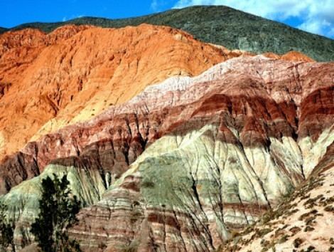 | ||
UNESCO region Latin America and the Caribbean Similar Cerro de los Siete Colores, Pucará de Tilcara, Calchaquí Valleys, Serranía de Hornocal, Quebrada de las Conchas | ||
Driving the ruta 40 the quebrada de humahuaca argentina
The Quebrada de Humahuaca is a narrow mountain valley located in the province of Jujuy in northwest Argentina, 1,649 km (1,025 mi) north of Buenos Aires (23°11′59″S 65°20′56″W). It is about 155 km (96 mi) long, oriented north-south, bordered by the Altiplano in the west and north, by the Sub-Andean hills in the east, and by the warm valleys (Valles Templados) in the south.
Contents
- Driving the ruta 40 the quebrada de humahuaca argentina
- Map of Quebrada de Humahuaca Jujuy Argentina
- Quebrada de humahuaca humahuaca province of jujuy northern argentina argentina
- References
Map of Quebrada de Humahuaca, Jujuy, Argentina
The name quebrada (literally "broken") translates as a deep valley or ravine. It receives its name from Humahuaca, a small city of 11,000 inhabitants. The Grande River (Río Grande), which is dry in winter, flows copiously through the Quebrada in the summer.
The region has always been a crossroads for economic, social and cultural communication. It has been populated for at least 10,000 years, since the settlement of the first hunter-gatherers, which is evidenced by substantial prehistoric remains. It was a caravan road for the Inca Empire in the 15th century, then an important link between the Viceroyalty of the Río de la Plata and the Viceroyalty of Peru, as well as a stage for many battles of the Spanish War of Independence.
The Quebrada de Humahuaca was made a UNESCO World Heritage Site on 2 July 2003.