
Country United States City St. Louis ZIP code(s) Parts of 63104, 63118 Area 2.927 km² Area code 314 | State Missouri Wards 7, 9 Website stlouis-mo.gov Population 14 (2010) | |
 | ||
Restaurants DB's Sports Bar, Bar 101 St Louis Soulard, Billie's Fine Foods, SUBWAY® Restaura, Panera Bread | ||
Kosciusko (Pronounced: kuh-SHOO-sco) is a mostly non-residential neighborhood located in St. Louis, Missouri. It begins at the Mississippi River front in the east and goes up to 7th Boulevard and 8th Street in the west. Interstate 55 is a northern border, and St. George and Dorcas Streets border the south of this neighborhood. Kosciusko is named in honor of Tadeusz Kościuszko, an American Revolutionary war general of Polish descent.
Contents
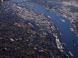
Map of Kosciusko, St. Louis, MO, USA
Within its limits are several industrial companies, including the Nooter Corporation. It is 42.9% White, 42.9% Black, 0% Asian, 0% American Indian, 0% Pacific Islander, 14.3% Two or more races with 0% being of Hispanic origin.
Schooling
The first independent charter middle school in the City is located in the neighborhood, as well. Lift for Life Academy, which opened in 2000, offers education for Grades 6 – 12.
Lyon Park
The City of Saint Louis maintains one city park within the Kosciusko boundaries: Lyon Park, named after Union Civil War General Nathaniel Lyon. It houses two softball fields, an asphalt walking trail, and both a monument to General Lyon (sculpted by Adolphus Druiding) and a statue of his likeness created by artist Charles Steubenraugh. Lyon Park is bounded by South Broadway, South Second Street, Utah Street, and Arsenal Street.