
Country Philippines Area 4,820.95 km2 Capital Tagbilaran Population 1,255,128 | Region Central Visayas Governor Edgar ChattoLP | |
 | ||
Colleges and Universities Bohol Island State University (Tagbilaran), University of Bohol (Tagbilaran), Holy Name University (Tagbilaran), BIT International College (Tagbilaran), Mater Dei College (Tubigon - Bohol) | ||
Languages spoken Cebuano, Boholano, Filipino, English | ||
Map of Bohol
Bohol is a 1st provincial income class island province of the Philippines located in the Central Visayas region, consisting of the island itself and 75 minor surrounding islands. Its capital is Tagbilaran. With a land area of 4,821 km2 (1,861 sq mi) and a coastline 261 km (162 mi) long, Bohol is the tenth largest island of the Philippines. To the west of Bohol is Cebu, to the northeast is the island of Leyte and to the south, across the Bohol Sea, is Mindanao.
Contents
- Map of Bohol
- The best of bohol beach resorts and island attractions
- Tour bohol philippines see the tourist attractions of bohol
- Early history
- Pre Hispanic Philippines
- Spanish colonial period
- US intervention and occupation
- Japanese occupation and liberation
- Recent history
- Geography
- Physical
- Earthquakes
- Islands
- Tarsier
- Climate
- Demographics
- Legislative districts
- Economy
- Airport
- Seaports
- Media
- Education
- References
The province of Bohol is a first-class province divided into 3 congressional districts, comprising 1 component city and 47 municipalities. It has 1,109 barangays.
The province is a popular tourist destination with its beaches and resorts. The Chocolate Hills, numerous mounds of brown-coloured limestone formations, are the most popular attraction. The formations can be seen by land (climbing the highest point) or by air via ultralight air tours. Panglao Island, located just southwest of Tagbilaran, is famous for its diving locations and is routinely listed as one of the top ten diving locations in the world. Numerous tourist resorts and dive centers dot the southern beaches. The Philippine tarsier, amongst the world's smallest primates, is indigenous to the island.
A strait separates Bohol from Cebu, and both island provinces share a common language, but the Boholanos retain a conscious distinction from the Cebuanos. Bohol's climate is generally dry, with maximum rainfall between the months of June and October. The interior is cooler than the coast.
It was the home province of Carlos P. Garcia, the eighth president of the Republic of the Philippines (1957–1961) who was born in Talibon, Bohol.
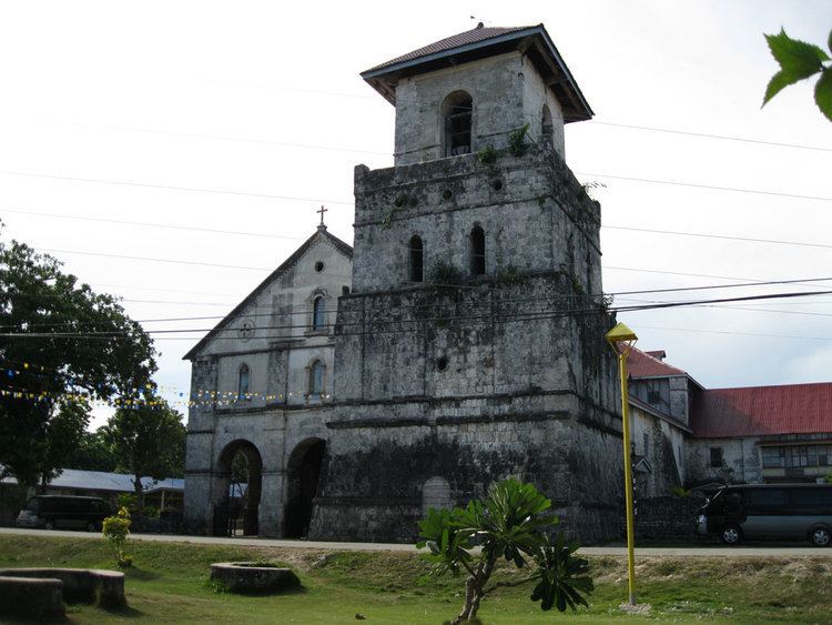
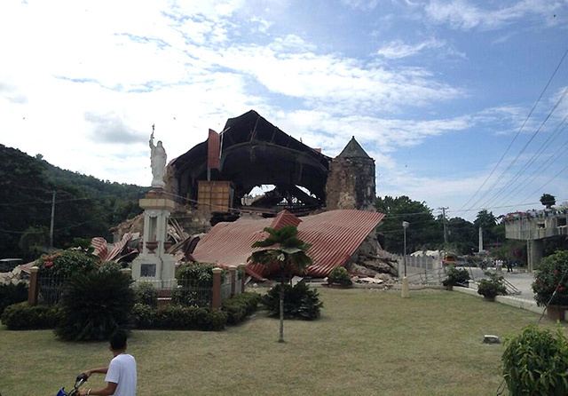
On 15 October 2013, Bohol was devastated by a 7.2 magnitude earthquake whose epicenter was 6 km (3.7 mi) south of Sagbayan town. The earthquake, which also hit southern Cebu, claimed 156 lives altogether and injured 374 people. It also destroyed or damaged a number of Bohol's heritage churches.
In 2017, militants with Abu Sayyaf Group links, clashed with the Armed Forces of the Philippines in combat on Bohol.
The best of bohol beach resorts and island attractions
Tour bohol philippines see the tourist attractions of bohol
Early history
Bohol was first settled by Australoid people, like the rest of the Philippines. They still inhabit the island today and are known as the Eskaya tribe. Their population also was absorbed into the Austronesian/Malayo-Polynesian peoples who later settled the islands and form the majority of the population. The Austronesian people living on Bohol traded with other islands in the Philippines and as far as China and Borneo.
The people of Bohol are said to be the descendants of a group of inhabitants who settled in the Philippines called pintados or "tattooed ones." Boholanos already had a culture of their own as evidenced by artifacts unearthed at Mansasa, Tagbilaran, and in Dauis and Panglao.
Pre-Hispanic Philippines
Bohol's first indigenous people settled in the Anda peninsula. These people came from northeast Mindanao. These people were responsible for the Anda petrographs which are one of the most important indigenous rock writing in the country. Around the 12th century, a group of people from Northern Mindanao settled in the strait between mainland Bohol and the island of Panglao. Those people came from a nation in northern Mindanao called Lutao (probably the animist kingdom of what will soon be the Islamic Lanao). Those people established the kedatuan (kingdom) of Dapitan in western Bohol because the true indigenous people of Bohol in the Anda peninsula and nearby areas were not open to them, forcing them to establish settlement in the western part of the island. They occupied both shores and the entire island of Panglao. The kedatuan was first built with hardwood on the soft seabed. It engaged it trade with nearby areas and some Chinese merchants.
Alcina tales about a rich nation he called the 'Venice of the Visayas', pointing to the kedatuan of Dapitan at that time. A legend tells of a princess named Bugbung Hamusanum, whose beauty caused her suitor, Datung Sumanga, to raid parts of southern China to win her hand.
By 1563, before the full Spanish colonization agenda came to Bohol, the kedatuan of Dapitan was at war with the Sultanate of Ternate in the Moluccas (who were also raiding the Rajahnate of Butuan). At the time, Dapitan was ruled by two brothers named Dailisan and Pagbuaya. The Ternateans at the time were allied to the Portuguese. Dapitan was destroyed and Datu Dailisan was killed in battle. His brother, Datu Pagbuaya, together with his people fled back to Mindanao and established a new Dapitan in the northern coast of the Zamboanga peninsula. When the Spanish came, the people of Dapitan were influential in the Spanish conquest of the Sultanate of Ternate and in the Christian colonization of northern Mindanao.
Bohol is derived from the word Bo-ho or Bo-ol. The island was the seat of the first international treaty of peace and unity between the native king Datu Sikatuna and Spanish conquistador Miguel López de Legazpi on 16 March 1565 through a blood compact alliance known today by many Filipinos as the Sandugo.
Spanish colonial period
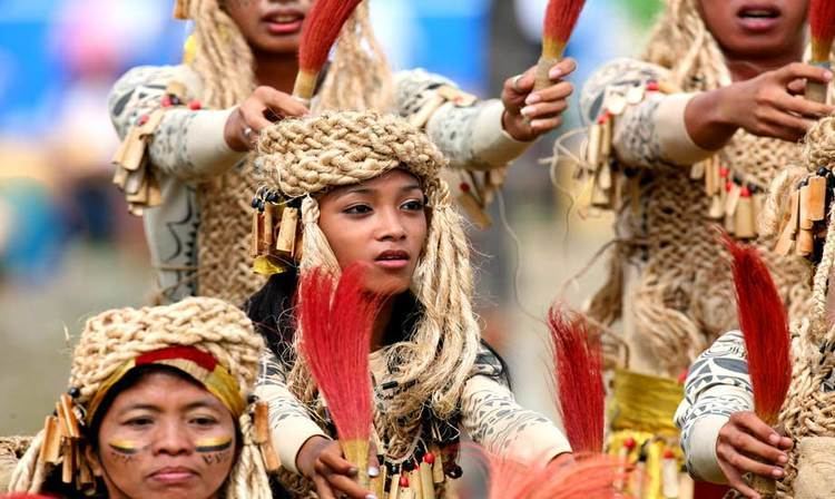
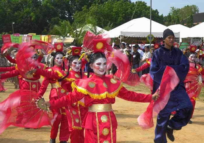
The earliest significant contact of the island with Spain occurred in 1565. On 25 March (16 March in the Julian calendar), a Spanish explorer named Miguel López de Legazpi arrived in Bohol seeking spices and gold. After convincing the native chieftains that they were not Portuguese (who raided the islands of Mactan in 1521), Legazpi made a peace pact with Datu Sikatuna. This pact was signified with a blood compact between the two men. This event, called the Sandugo ("one blood"), is celebrated in Bohol every year during the Sandugo Festival. The Sandugo or blood compact is also depicted on Bohol's provincial flag and the Bohol provincial seal.
Two significant revolts occurred in Bohol during the Spanish Era. One was the Tamblot Uprising in 1621, led by Tamblot, a babaylan or native priest. The other was the famous Dagohoy Rebellion, considered the longest in Philippine history. This rebellion was led by Francisco Dagohoy, also known as Francisco Sendrijas, from 1744 to 1829.
Politically, Bohol was administered as a residencia of Cebu. It became a separate politico-military province on 22 July 1854 together with Siquijor. A census in 1879 found Bohol with a population of 253,103 distributed among 34 municipalities.
The culture of the Boholanos was influenced by Spain and Mexico during colonization. Many traditional dances, music, dishes and other aspects of the culture have considerable Hispanic influence.
U.S. intervention and occupation
After the United States defeated Spain in the Spanish–American War, the U.S. bought the entire Philippine islands. However, under the newly proclaimed independent government established by Gen. Emilio Aguinaldo, which was not recognized by the U.S., Bohol was governed as a Gobierno de Canton.
During the resulting Philippine–American War, American troops peacefully took over the island in March 1899. However, in January 1901, Pedro Sanson led 2,000 in rebellion, due to the harsh treatment imparted by these troops and the destruction they caused. General Hughes led a campaign of repression in October 1901, destroying a number of towns, and threatening in December 1901 to burn Tagbilaran if the rebels did not surrender. Pantaleon E. del Rosario then negotiated the rebel surrender.
On 10 March 1917, the Americans made Bohol a separate province under Act 2711 (which also established most of the other Philippine provinces).
Japanese occupation and liberation
Japanese troops landed in Tagbilaran on 17 May 1942. Boholanos struggled in a guerilla resistance against the Japanese forces. Bohol was later liberated by the local guerrillas and the Filipino and American troops who landed on 11 April 1945.
A plaque placed on the port of Tagbilaran commemorating the liberation reads:
One thousand one hundred seventy two officers and men of the 3rd Battalion of the 164th Infantry Regiment of the Americal Division under the command of Lt. Col. William H. Considine landed at the Tagbilaran Insular Wharf at 7:00 o'clock in the morning of April 11, 1945.
The convoy taking the Filipino and American liberation forces to Bohol consisted of a flotilla of six landing ships (medium), six landing crafts (infantry), two landing crafts (support), and one landing craft (medium-rocket). Upon arrival, the reinforced battalion combat team advanced rapidly to the east and northeast with the mission of destroying all hostile forces in Bohol. Motor patrols were immediately dispatched by Col. Considine, Task Force Commander, and combed the area to the north and east, approximately halfway across the island, but no enemies were found during the reconnaissance. Finally, an enemy group of undetermined strength was located to the north of Ginopolan in Valencia, near the Sierra-Bullones boundary.
By 17 April the Task Force was poised to strike in Ginopolan. The bulk of the Japanese force was destroyed and beaten in the ten days of action. Bohol was officially declared liberated on 25 May 1945 by Major General William H. Arnold, Commander of the Americal Division. About this time, most officers and men of the Bohol Area Command had been processed by units of the Eighth United States Army.
On 31 May 1945, the Bohol Area Command was officially deactivated upon orders of Lt. General Robert L. Eichelberger, Commanding General of the Eighth United States Army, together with the regular and constable troops of the Philippine Commonwealth Army, Philippine Constabulary, and the Boholano guerrillas.
During the Second Battle of Bohol from March to August 1945, Filipino troops of the 8th, 83rd, 85th and 86th Infantry Division of the Philippine Commonwealth Army and 8th Constabulary Regiment of the Philippine Constabulary captured and liberated the island province of Bohol and helped the Boholano guerrilla fighters and U.S. liberation forces defeat the Japanese Imperial forces under General Sōsaku Suzuki.
Recent history
On 12 April 2017, 11 Abu Sayyaf Group (ASG) terrorists staged an attack on Bohol. Three soldiers, a police officer and at least 6 of the armed men, including their leader Abu Rami, were killed in the clashes that started at 5 am. Also killed were two Inabanga villagers, though it was not clear whether they were killed in the crossfire or executed by the cornered militants. Security officials relentlessly hunted down the remainder of the ASG who landed in Bohol from the hinterlands to a neighboring island in the province which ultimately led to the neutralization of Abu Asis, the last of the remaining bandits, in May. He was gunned down by police Special Weapons and Tactics operatives in Barangay Lawis, Calape while fighting it out to the end along with Ubayda. Despite their nefarious intents, all 11 ASG members killed in the intrusion were given proper burials under Muslim tradition.
The tourism industry in Bohol was negatively affected by the ASG militants' incursion on the island, though tour operators believe the industry can recover.
Geography
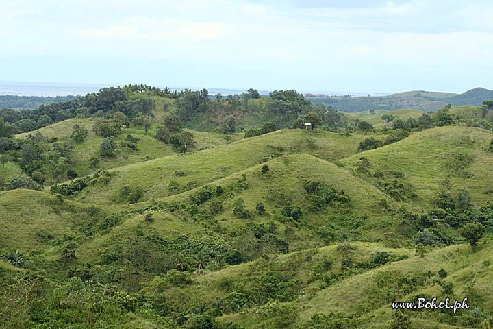
The Chocolate Hills are considered one of Philippine's natural wonders and Bohol is often referred to as the Jewel of the Philippines. They are hills made of limestone left over from coral reefs during the Ice Age when the island was submerged. They turn brown during the summer.
There are four main rivers that run through Bohol, with the Loboc River running from the center of the island to the mid-southern coast. The largest river, the Inabanga, runs in the northwestern part of the province; the Abatan River runs in the southwest, and Ipil River in the north.
Numerous waterfalls and caves are scattered across the island, including Mag‑Aso Falls in Antequera. Mag‑Aso means smoke in the native tongue. The water is cool and often creates a mist in humid mornings which can hide the falls.
The Rajah Sikatuna Protected Landscape protects Bohol's largest remaining lowland forest and can be found in the island's southern portion near Bilar.
Physical
With a land area of 4,821 km2 (1,861 sq mi) and a coastline 261 km (162 mi) long, Bohol is the tenth largest island of the Philippines. The main island is surrounded by about 70 smaller islands, the largest of which are Panglao Island, facing Tagbilaran, in the southwest and Lapinig Island in the northeast.
The terrain of Bohol is basically rolling and hilly, and about half the island is covered in limestone. Near the outer areas of the island are low mountain ranges. The interior is a large plateau with irregular landforms.
Near Carmen, the Chocolate Hills are more than 1,200 uniformly cone-shaped limestone hills named for the grass growing on the hills that turns brown in the summer, making the landscape look like chocolate mounds. The Chocolate Hills appear on the provincial seal of Bohol.
Earthquakes
At 8:12 a.m. (PST) on 15 October 2013, the island province suffered a severe earthquake with a magnitude of 7.2 on the Richter scale. Its epicenter was at 9°52′N 124°04′E (6 km (3.7 mi) S 24° W of Sagbayan and 629 km (391 mi) from Manila), and its depth of focus was 12 km (7.5 mi). The quake was felt as far as Davao City, Mindanao. According to official reports by the National Disaster Risk Reduction and Management Council (NDRRMC), 57 people died in Bohol, and 104 were injured.
It was the deadliest earthquake in the Philippines since the 7.8 magnitude 1990 Luzon earthquake. Earlier that same year Bohol was struck by an earthquake (on 8 February 1990) with an epicentre almost exactly the same as in 2013, causing six fatalities and 200 injured. Several buildings were damaged and it caused a tsunami.
Islands
The 75 outlying islands surrounding mainland Bohol under the jurisdiction of the Bohol Provincial Government are:
Tarsier
In 1996 the Philippine Tarsier Foundation was established in Corella, Bohol in efforts to help conserve and protect tarsiers and their habitat. Forest and habitat sanctuaries have been created to ensure the safety of tarsiers while allowing visitors to roam and discover these miniature primates in their natural habitats.
The tarsier is the smallest living primate that exists in several South East Asian countries today. The Philippine tarsier, Tarsius syrichta, locally known as "mamag" in Boholano is near to threatened according to the IUCN Red List of Endangered Species. Adaptation to their large bulging eyes allows them to catch prey clearly at night, and with elongated limbs and fingers, leaping from tree to tree gives no limitation to the tarsier. Their brain is about the same size as their eyes. The connection between its eyes and brain serves a unique function to these animals which is important for their stability and balance. Tarsiers have incredible hearing abilities. They can hear a frequency of up to 91 kHz (kilohertz) and send sounds of 70 kHz.
Climate
From November to April, the northeast monsoon (amihan) prevails. Except for a rare shower, this is the mildest time of the year. Daytime temperatures average 28 °C (82 °F), cooling at night to around 25 °C (77 °F). The summer season from May to July brings higher temperatures and very humid days. From August to October is the southwest monsoon (habagat). The weather during this season is not very predictable, with weeks of calm weather alternating with rainy days. It can rain any day of the year, but a higher chance of heavy showers occurs from November to January.
Demographics
According to the 2015 census, it has a population of 1,313,560. In the 2016 electoral roll, it had 798,768 registered voters, meaning that 61% of the population are aged 18 and over.
Legislative districts
Economy
Tourism plays an increasing role in the island's economy. The Panglao Island International Airport is currently planned for Panglao, which houses the most-visited and accessible beaches in the province. Proponents of the scheme hope that the new airport will increase Bohol's reputation as an international tourist destination although the plan has been dogged by ongoing criticism.
Airport
Though a number of national flag carriers serve the Tagbilaran Airport, a proposed international airport (see Panglao Island International Airport) has been planned on nearby Panglao Island to accommodate bigger aircraft and handle larger volumes of passengers and tourists to the province. The Panglao airport project is controversial. Private land in the planned right-of-way that was bought cheaply is being sold expensively, creating further issues and delays.
Seaports
Port of Tubigon, the busiest among the smaller ports, offers more than ten daily round trips plying the Cebu-Bohol route. Catagbacan Port in Loon serves the roll-on roll-off services between Cebu and Bohol for those who have vehicles. Port of Jagna offers service between Bohol to Cagayan and Camiguin (with roll-on/roll-off) route. The other ports are Ubay, Talibon, Getafe, Buenavista, and Clarin.
Media
Bohol has 2 major AM radio stations, DYRD and DYTR, both based in Tagbilaran City. Another AM radio station, DYZD, based in Ubay, is being operated by DYRD. Both DYRD and DYTR also operate FM stations with the same names. There are multiple weekly or twice weekly newspapers like Sunday Post, Bohol Times, Bohol Standard and Bohol Bantay Balita. These days Bohol Chronicle is now a daily paper. An online news website called Bohol News Daily aggregates news from various sources.
Education
The literacy rate of the province of Bohol is high at 98%.
Institutions of Higher Learning are: